Skip to content

Geomorphology: Landforms & Exogenic Processes

Exogenic Forces & Weathering Systems


Denudation & Mountain Systems

Denudation & Mountain Systems
Define Exogenic forces and explain the denudation process.Denudation Mechanics:
  • Exogenic Forces: Surface-shaping processes powered by solar energy and gravitational pull.
  • Denudation: The continuous wear-down and reshaping of the landscape. It is the sum of three processes:
    • Weathering: In-situ disintegration and decomposition of rocks.
    • Mass Wasting: Downslope movement of rock debris under the direct influence of gravity.
    • Erosion: The active wearing away and acquisition of rock debris by geomorphic agents, followed by transportation and deposition.
Classify the major types of mountain systems and provide key UPSC examples.Mountain Classification:
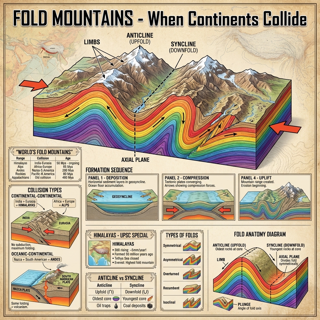
  • Fold Mountains: Formed by tectonic compression of sedimentary strata at convergent plate boundaries (e.g., Himalayas, Alps, Rockies).
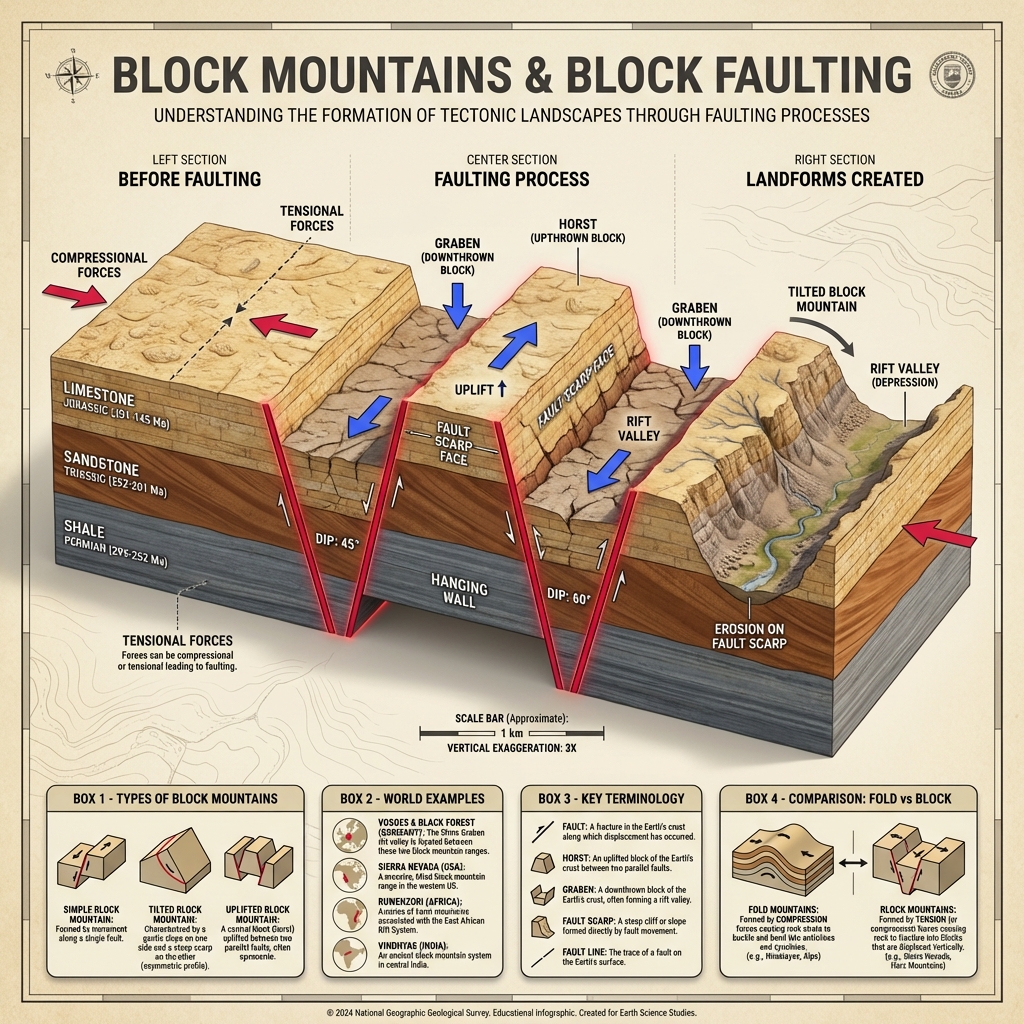
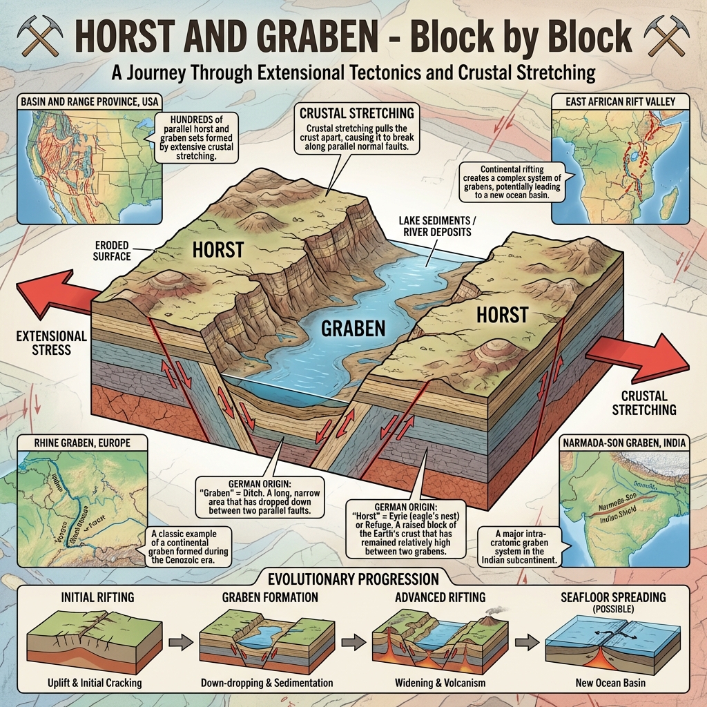
  • Block Mountains: Created when tectonic forces crack the crust, leading to faulting. Central lowered blocks form a Rift Valley (Graben), and elevated blocks form a Horst (e.g., Satpura Range, Black Forest).
  • Residual Mountains: Weathered and eroded remnants of ancient mountain systems that have been stripped of softer strata over geological eras (e.g., Aravallis, Nilgiris).

Plateaus, Plains & Weathering Mechanics

Plateaus, Plains & Weathering Mechanics
Describe the classes of plateaus and plains.Uplands & Lowlands:
  • Plateaus: Elevated flat-topped structures.
    • Tibetan Plateau: Highest in the world; an Intermountain plateau bounded by mountain ranges.
    • Deccan Plateau: Formed by flood basalt eruptions (volcanic origin).
  • Plains: Flat, low-lying lands.
    • Depositional: Silt deposits from rivers (e.g., Indo-Gangetic Plains).
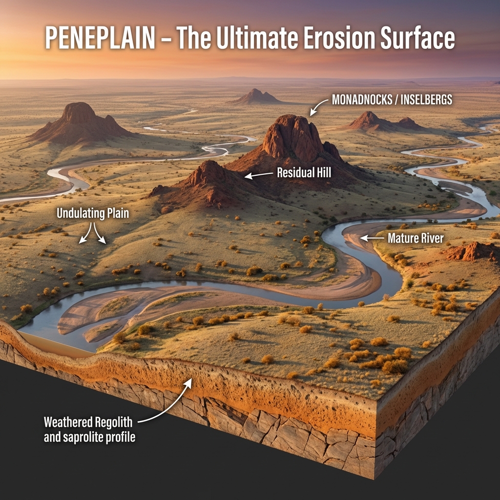
    • Erosional: Peneplains formed by continuous long-term denudation.
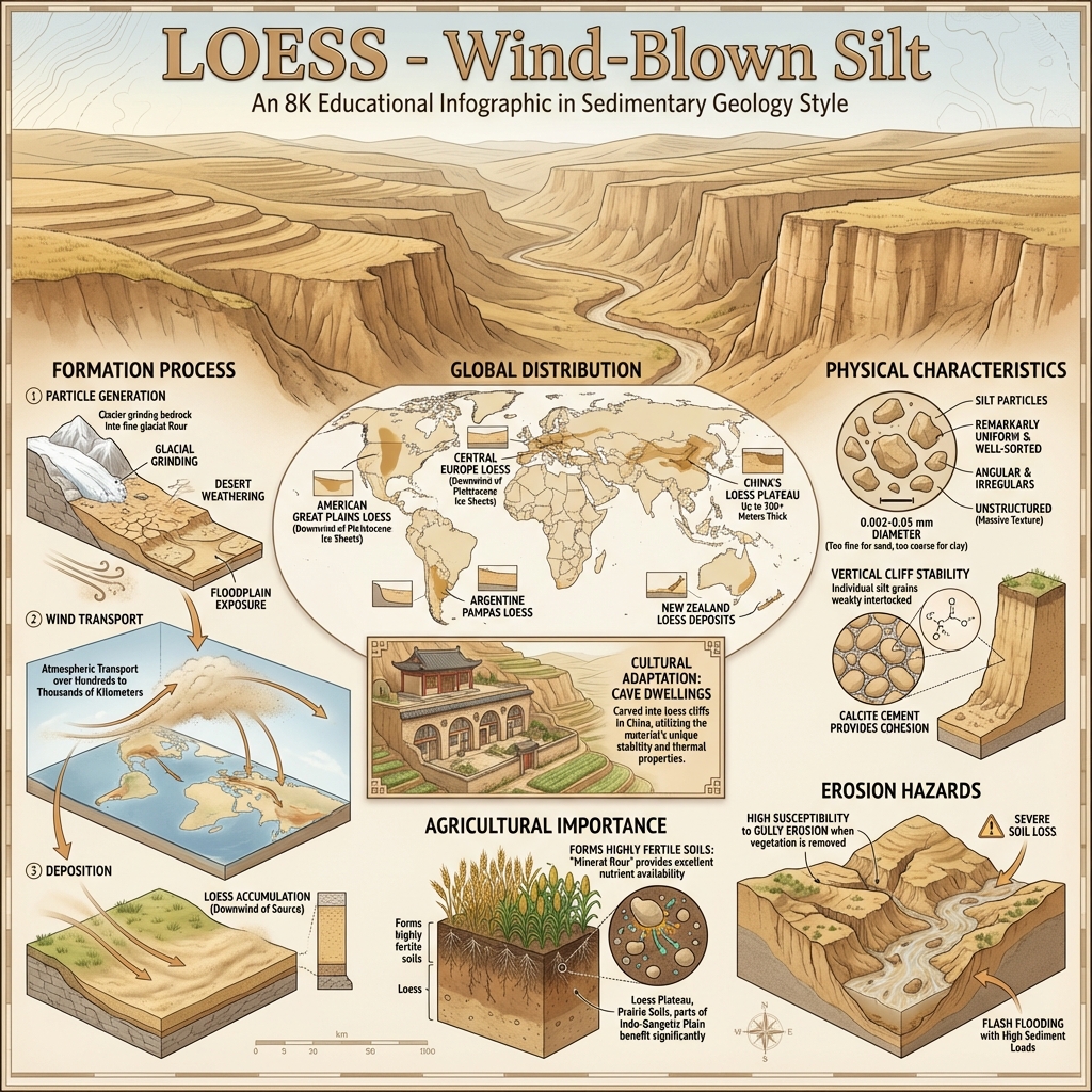
    • Loess Plains: Formed by wind-blown deposits of fine, porous silt (e.g., Loess Plateau, China).
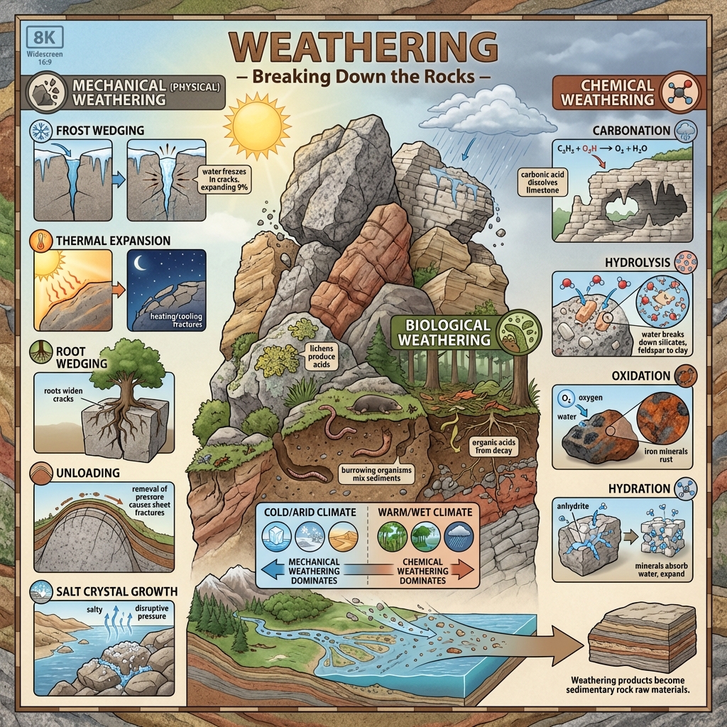
Contrast mechanical and chemical weathering and list their primary sub-types.Weathering Classifications:
  • Mechanical (Physical) Weathering: In-situ physical fragmentation without chemical alteration:
    • Freeze-Thaw (Frost Wedging): Water expands by 9% upon freezing in rock joints, shattering rock.
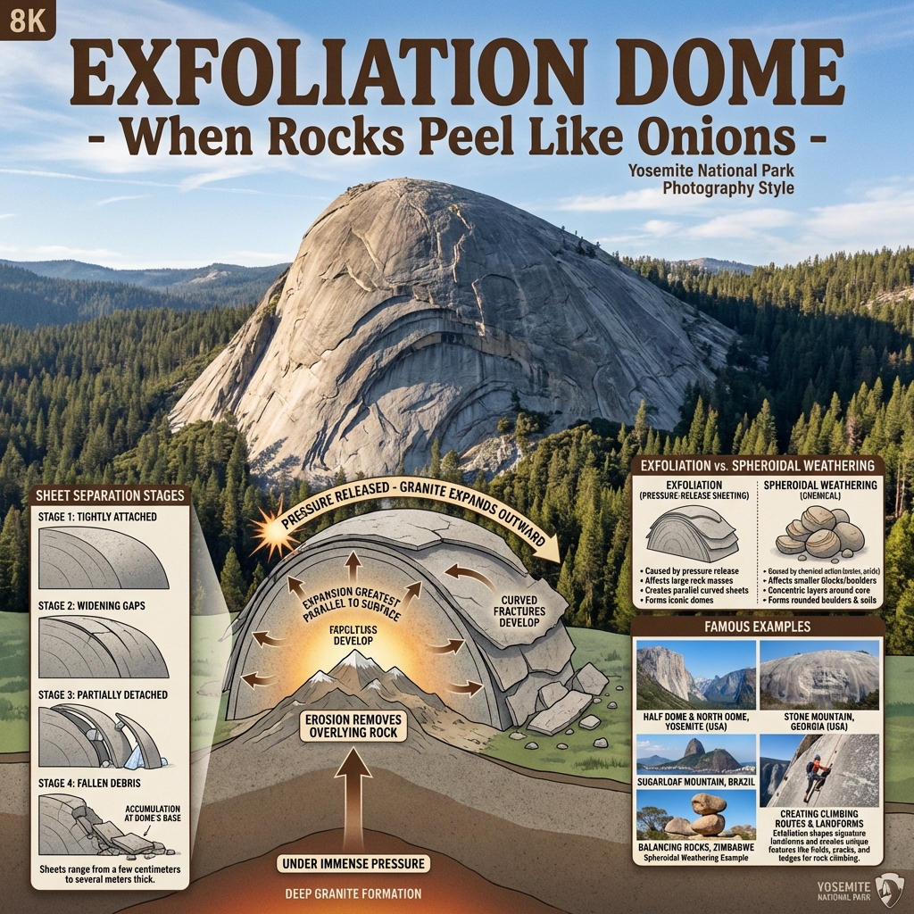
    • Exfoliation: Thermal expansion/contraction or pressure release (unloading) causes outer layers of rock to peel away in sheets (Exfoliation Domes).
  • Chemical Weathering: Chemical decomposition of mineral structures:
    • Carbonation: Carbon dioxide in rainwater forms weak carbonic acid ($H_2CO_3$), dissolving limestone.
    • Oxidation: Iron minerals react with oxygen to form rust (rusting of rocks).
    • Hydrolysis: Water reacts with silicate minerals (e.g., feldspar) to form clay.
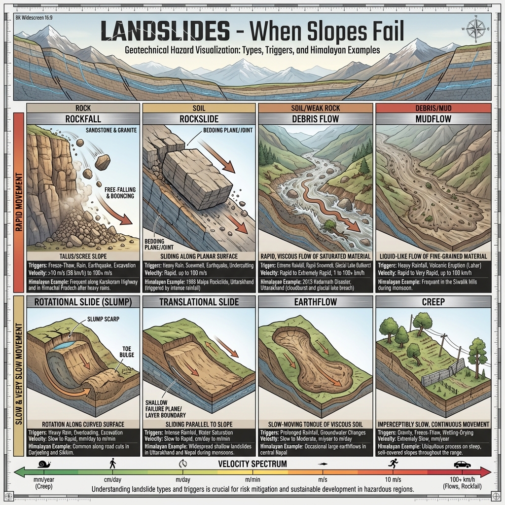
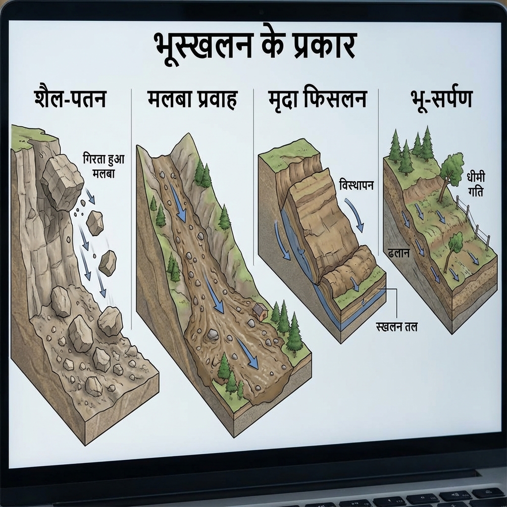
Define mass wasting and name its major forms.Mass Wasting (Gravity Movement):
The downslope transfer of weathered material under the direct force of gravity (without an active geomorphic agent like water, wind, or ice). Major forms include:
  • Rapid Movements: Landslides, debris slides, and mudflows.
  • Slow Movements: Soil creep (slow imperceptible downslope bending of soil layers).

Geomorphic Agents & Landform Evolution


Fluvial (Running Water) Landforms

Fluvial (Running Water) Landforms
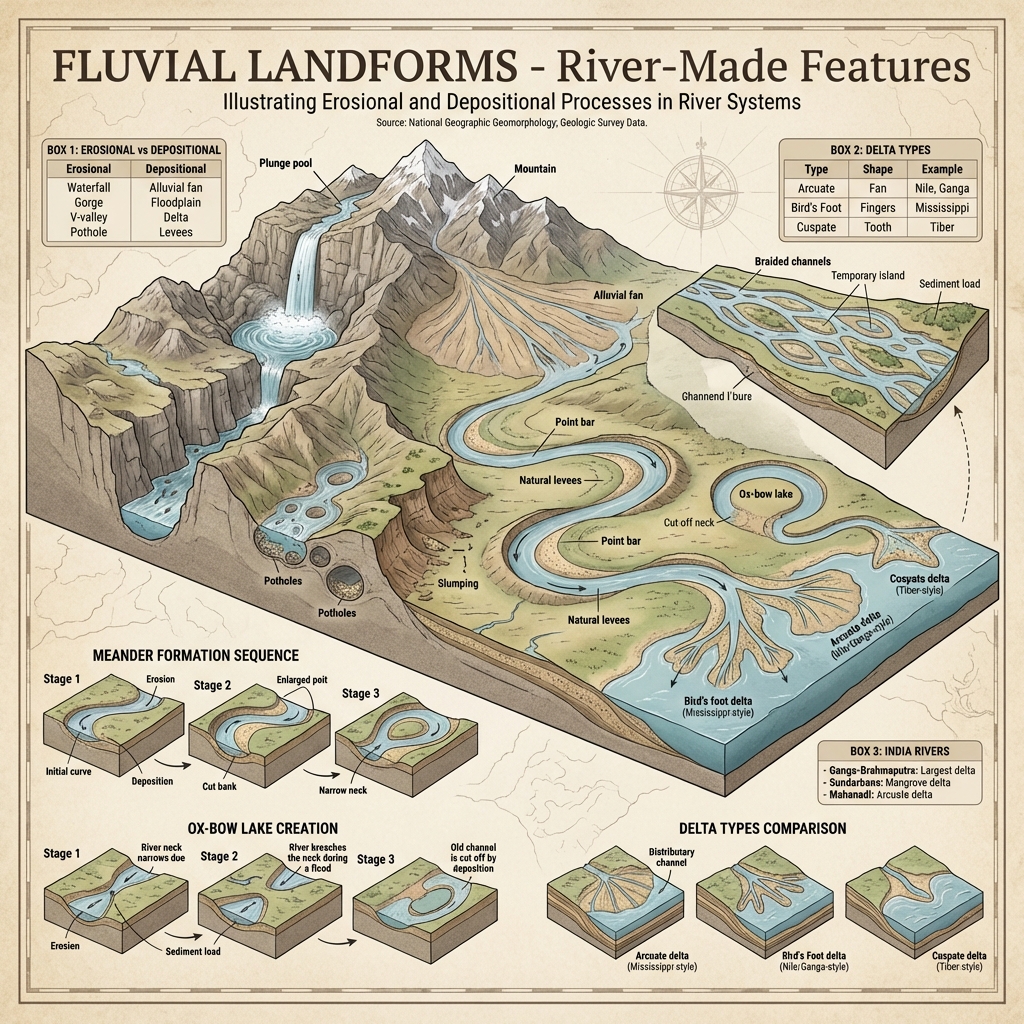
Distinguish between erosional and depositional fluvial landforms.Fluvial Systems (Running Water):
  • Erosional Features:
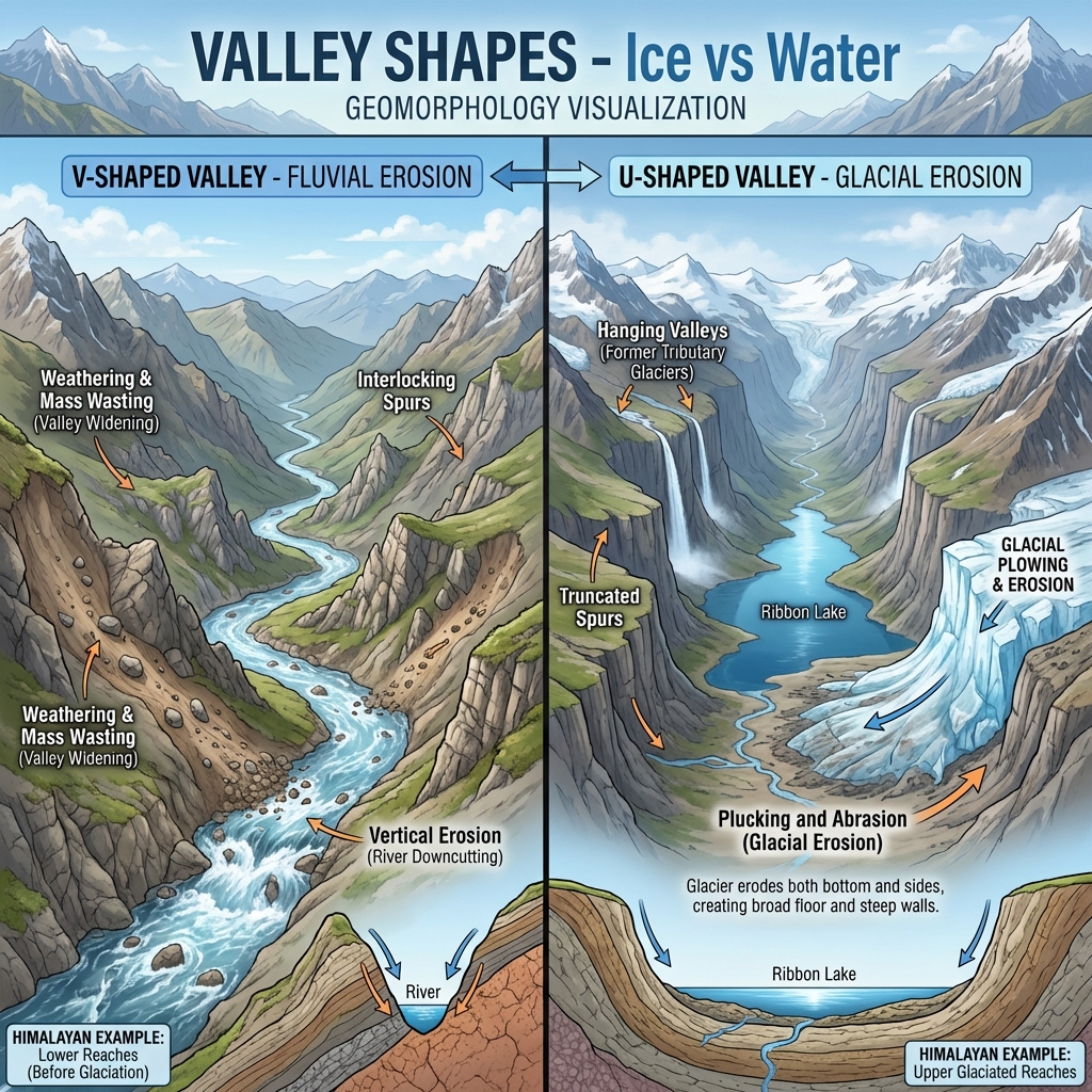
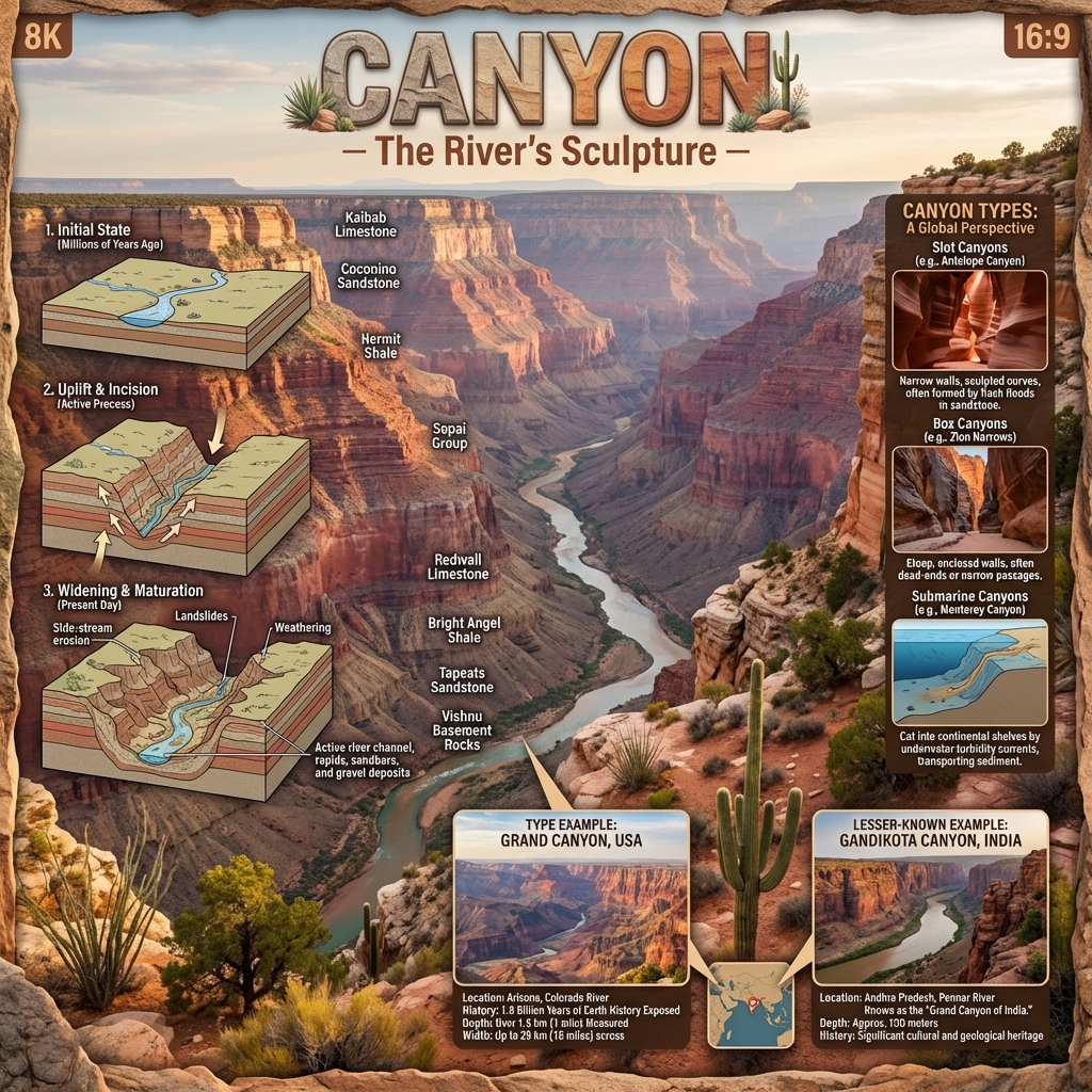
    • V-Shaped Valleys & Gorges: Formed by vertical downcutting in youthful mountain stages (e.g., Grand Canyon).
    • Waterfalls & Potholes: Vertical plunges over resistant strata and cylindrical depressions drilled into riverbeds by rotating pebbles.
  • Depositional Features:
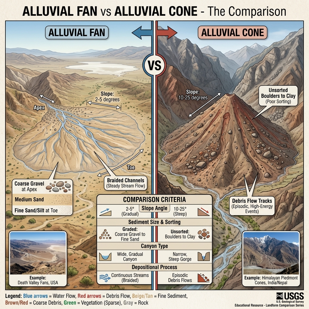
    • Alluvial Fans & Cones: Fan-shaped debris deposits built where steep mountain streams debouch onto flat plains.
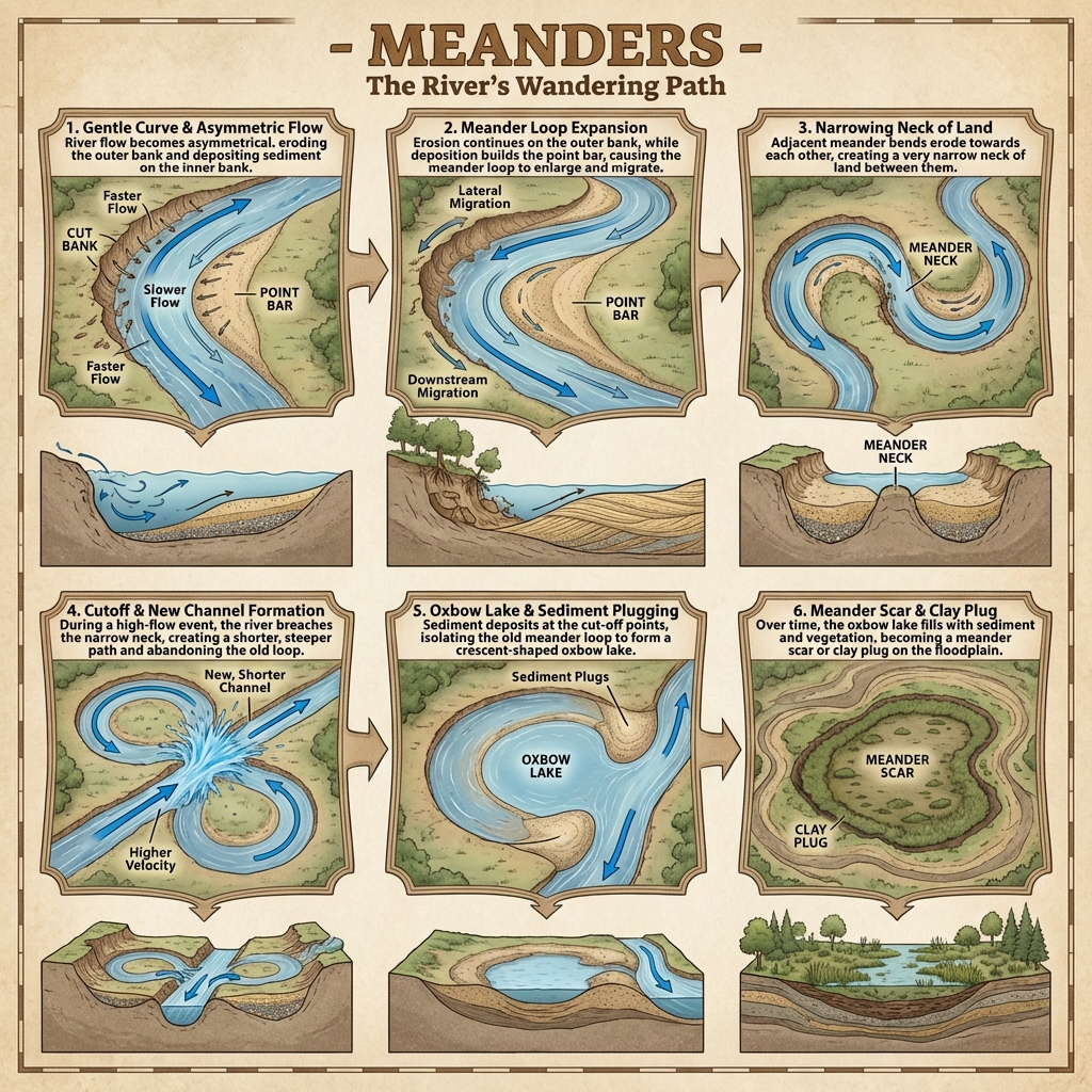
    • Flood Plains & Meanders: Broad flat valleys prone to flooding, where lateral erosion produces loops (meanders) that can pinch off into Ox-bow Lakes.
    • Deltas: Depositional landforms built at river mouths where sediment loads deposit into standing water bodies.
Name the primary types of river deltas and highlight Sundarbans.Deltaic Typologies & Sundarbans:
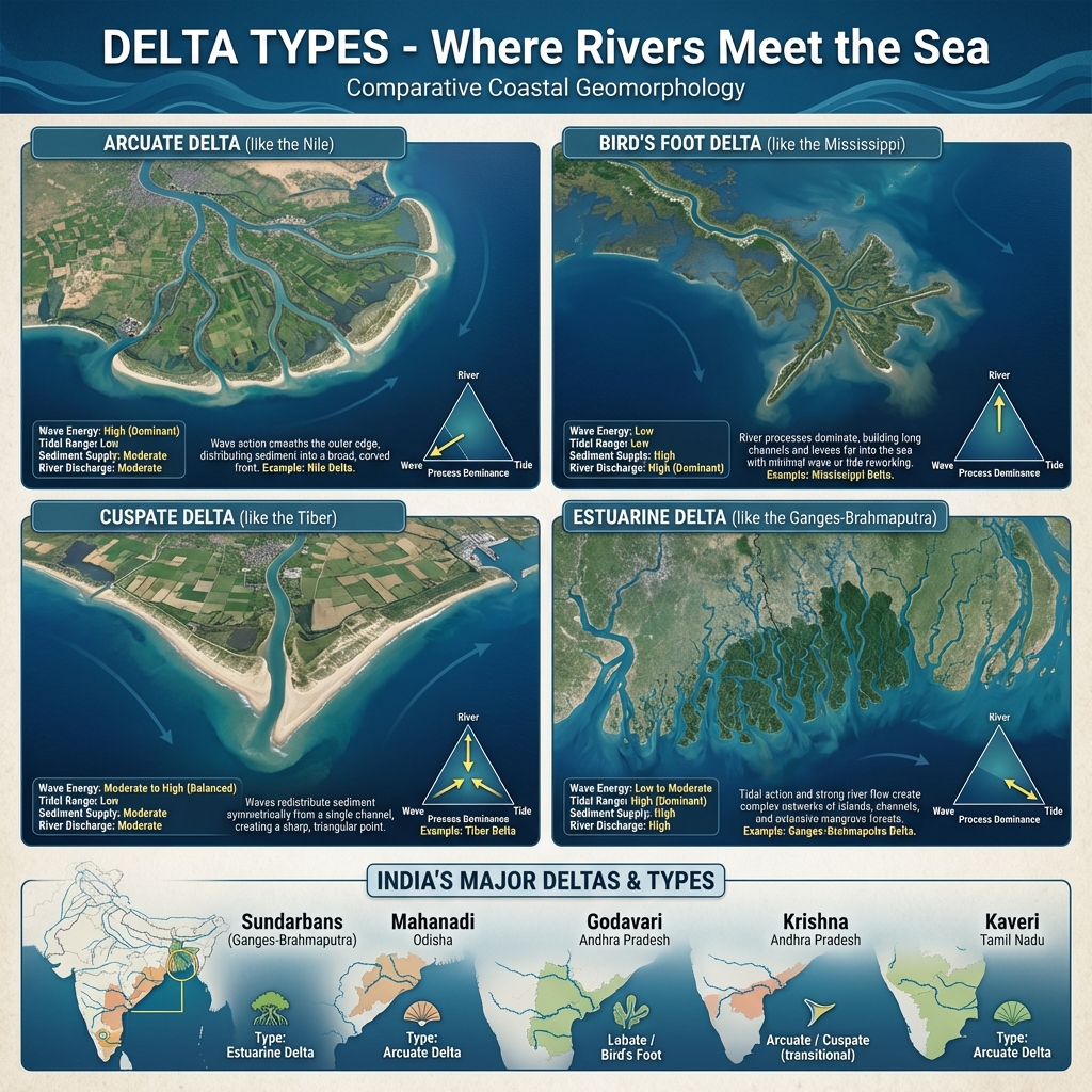
  • Arcuate: Fan-shaped or triangular delta pointing outwards (e.g., Nile Delta, Ganges Delta).
  • Bird's Foot: Finger-like distributaries projecting into the sea (e.g., Mississippi Delta).
  • Cuspate: Tooth-shaped, formed by wave action smoothing the margins (e.g., Tiber Delta).
  • Sundarbans Delta: The world's largest deltaic system, formed by the confluence of the Ganges, Brahmaputra, and Meghna rivers, hosting the largest single block of halophytic mangrove forest.

Glacial (Moving Ice) Landforms

Glacial (Moving Ice) Landforms
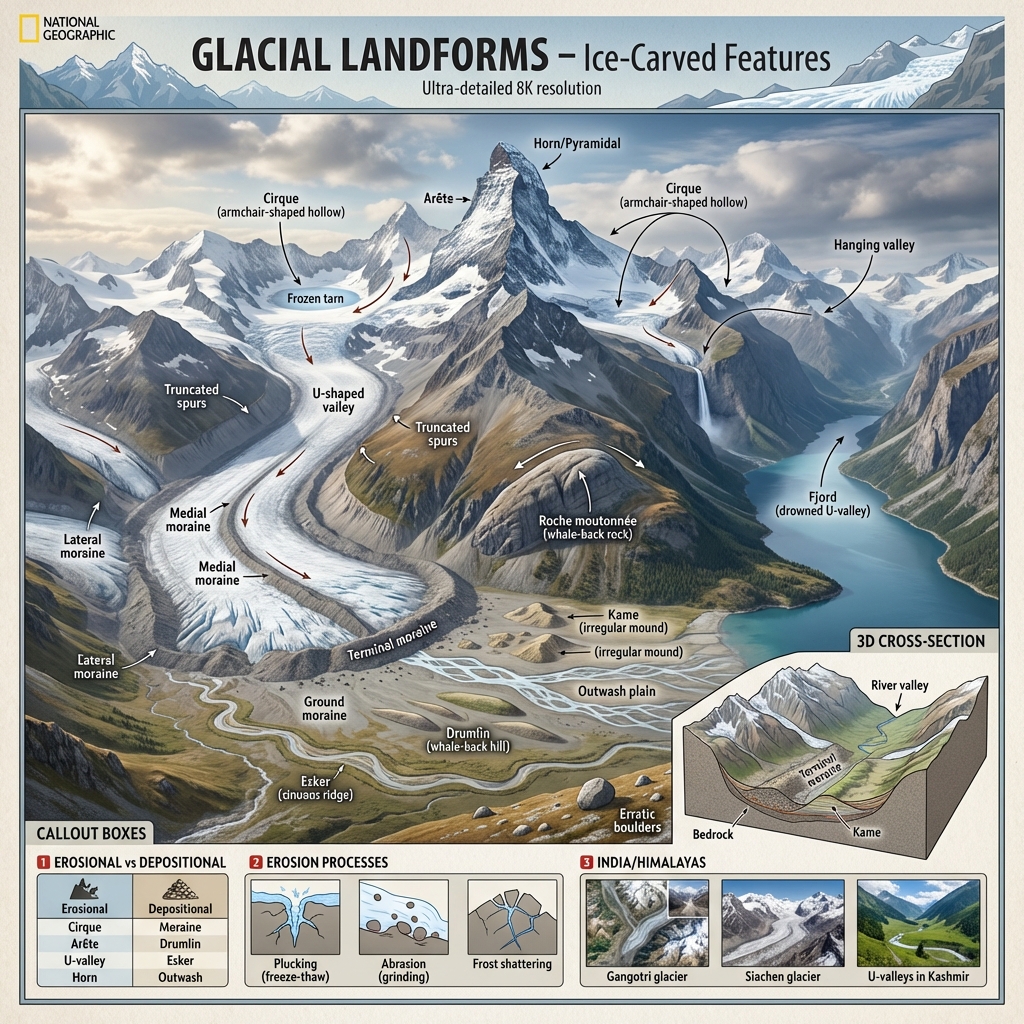
Distinguish between erosional and depositional glacial landforms.Glacial Landforms:
  • Erosional Features:
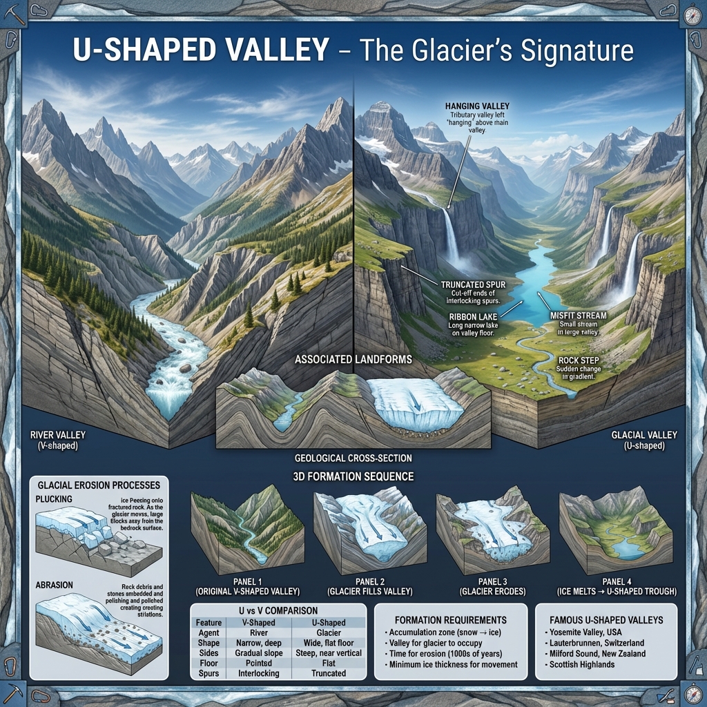
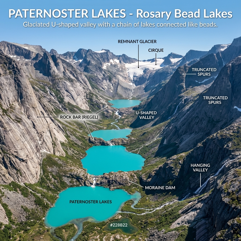
    • U-Shaped Valleys (Glacial Troughs): Steep-sided, flat-bottomed valleys formed by glacial scouring.
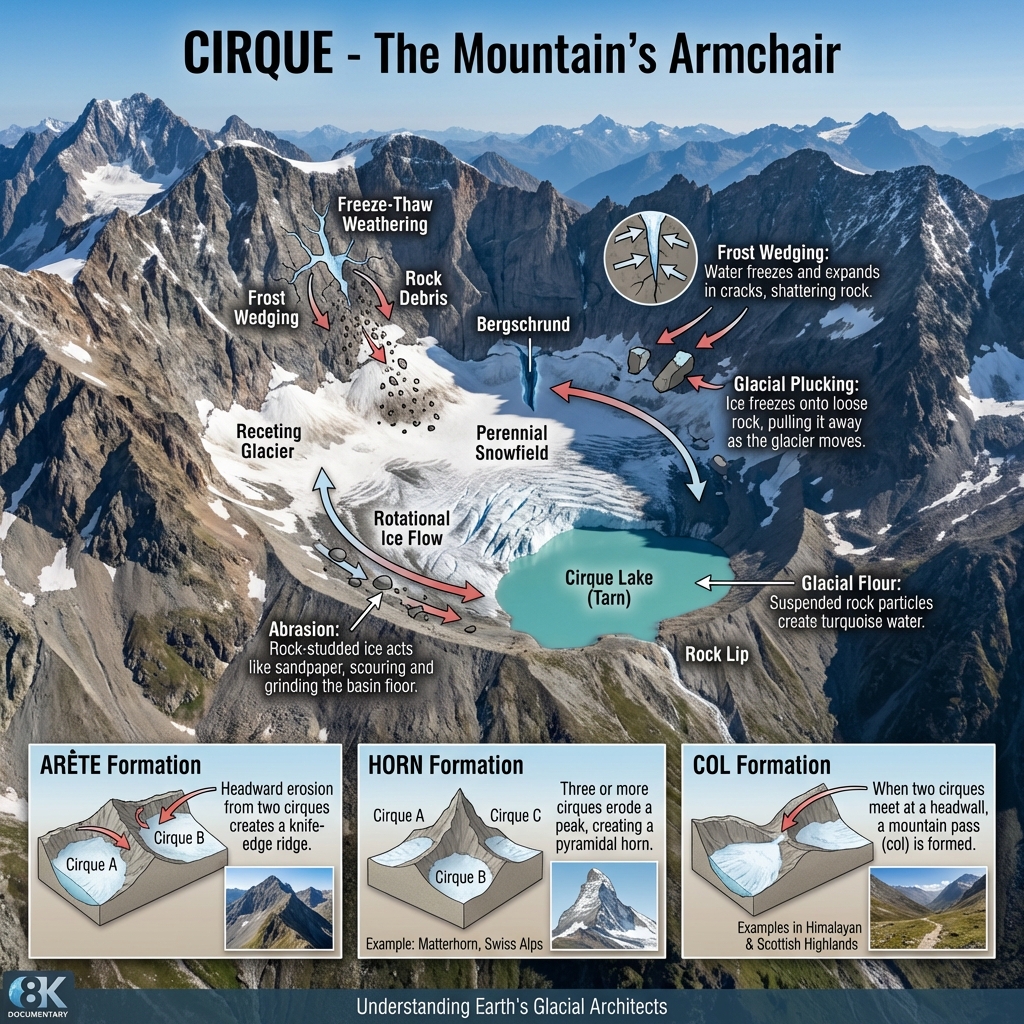
    • Cirques & Arêtes: Armchair-shaped depressions and knife-like rock ridges between adjacent cirques.
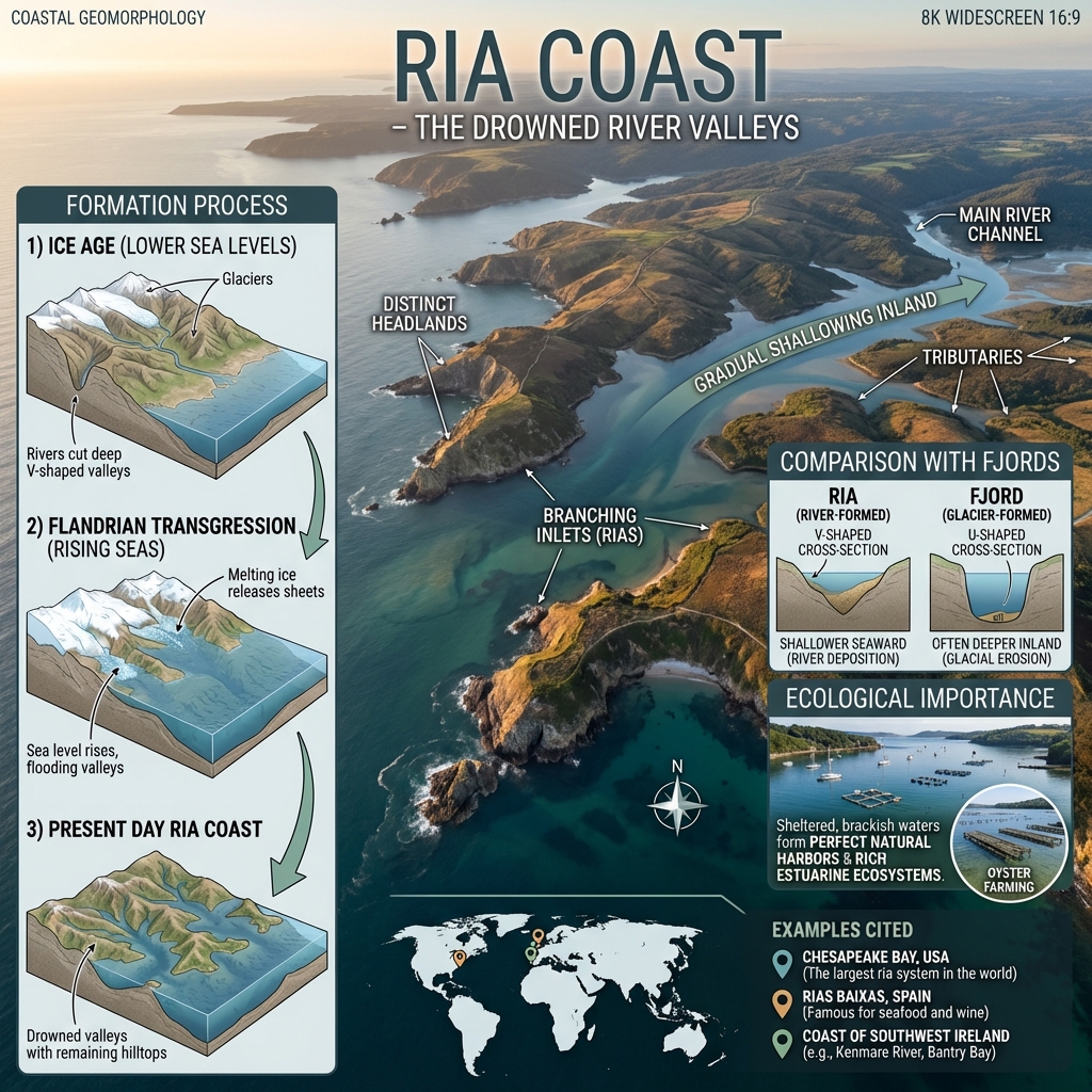
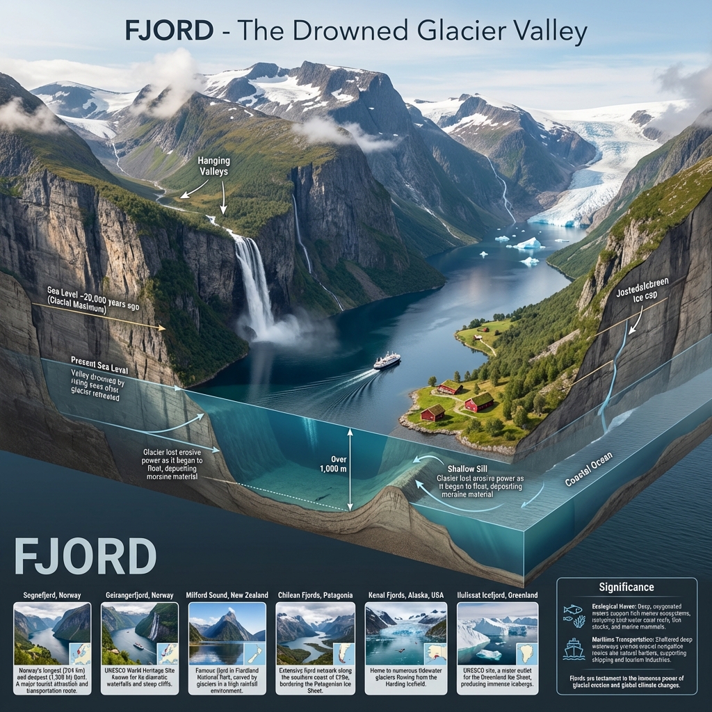
    • Fiords (Fjords): Deeply scoured glacial valleys that have been partially submerged by the sea.
  • Depositional Features:
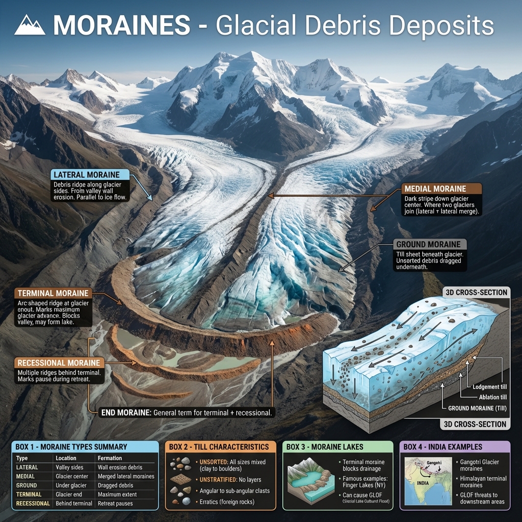
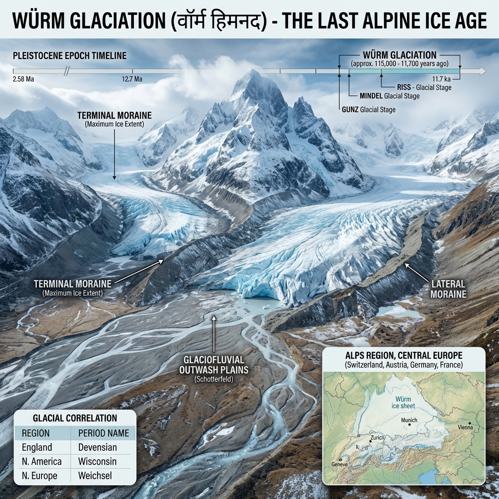
    • Moraines: Glacial debris (till) deposited at the margins (Lateral moraine) or front snout (Terminal moraine) of a glacier.
    • Drumlins: Smooth oval-shaped hills of till resembling inverted spoons or "basket of eggs" topography.
    • Eskers: Winding ridges of sand/gravel deposited by subglacial streams flowing in ice tunnels.
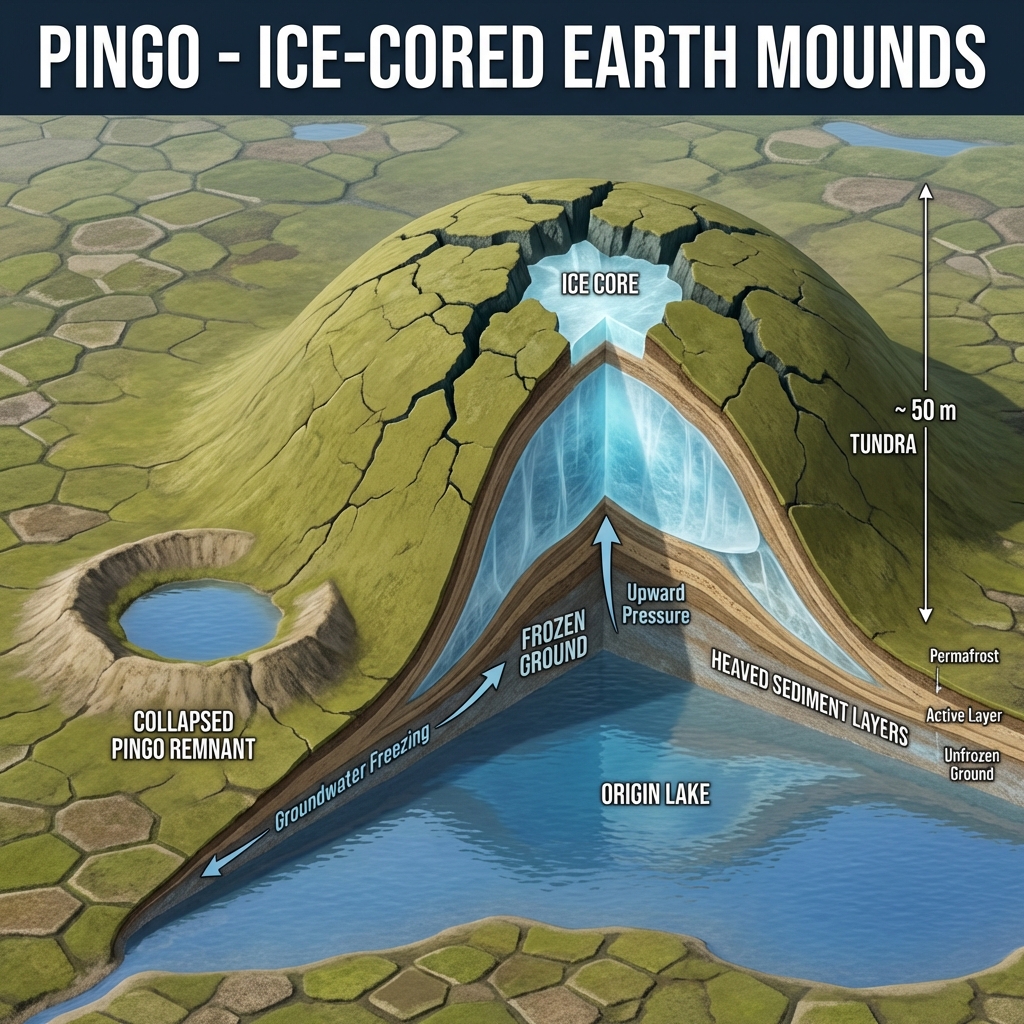
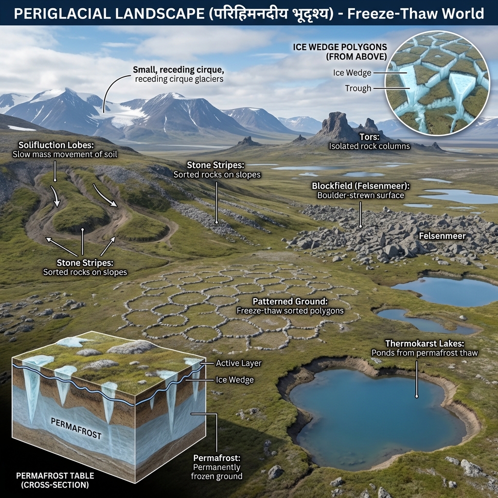
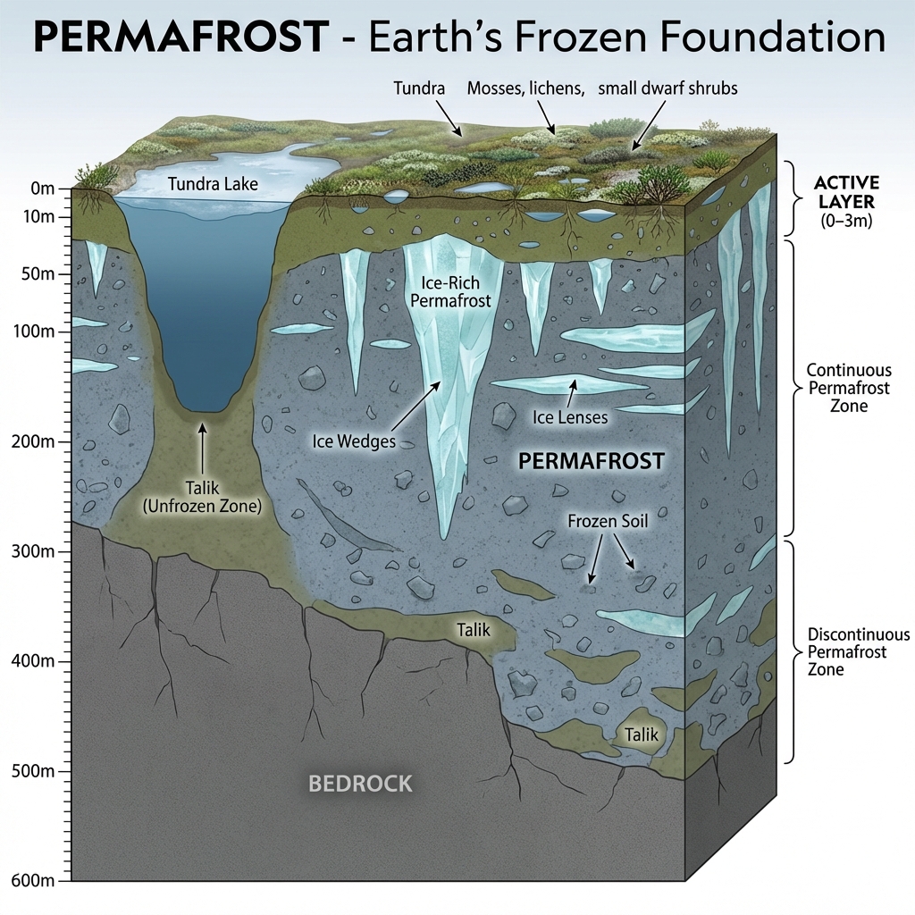
Describe periglacial permafrost structures and the formation of a Pingo.Periglacial (Permafrost) Features:
  • Active Layer: The upper layer of permafrost that thaws in summer and freezes in winter.
  • Pingo (Hydrolaccolith): An ice-cored mound or hill found in permafrost areas, formed as groundwater freezes under pressure, pushing up the overlying soil.

Aeolian (Wind) & Karst (Groundwater) Systems

Aeolian (Wind) & Karst (Groundwater) Systems
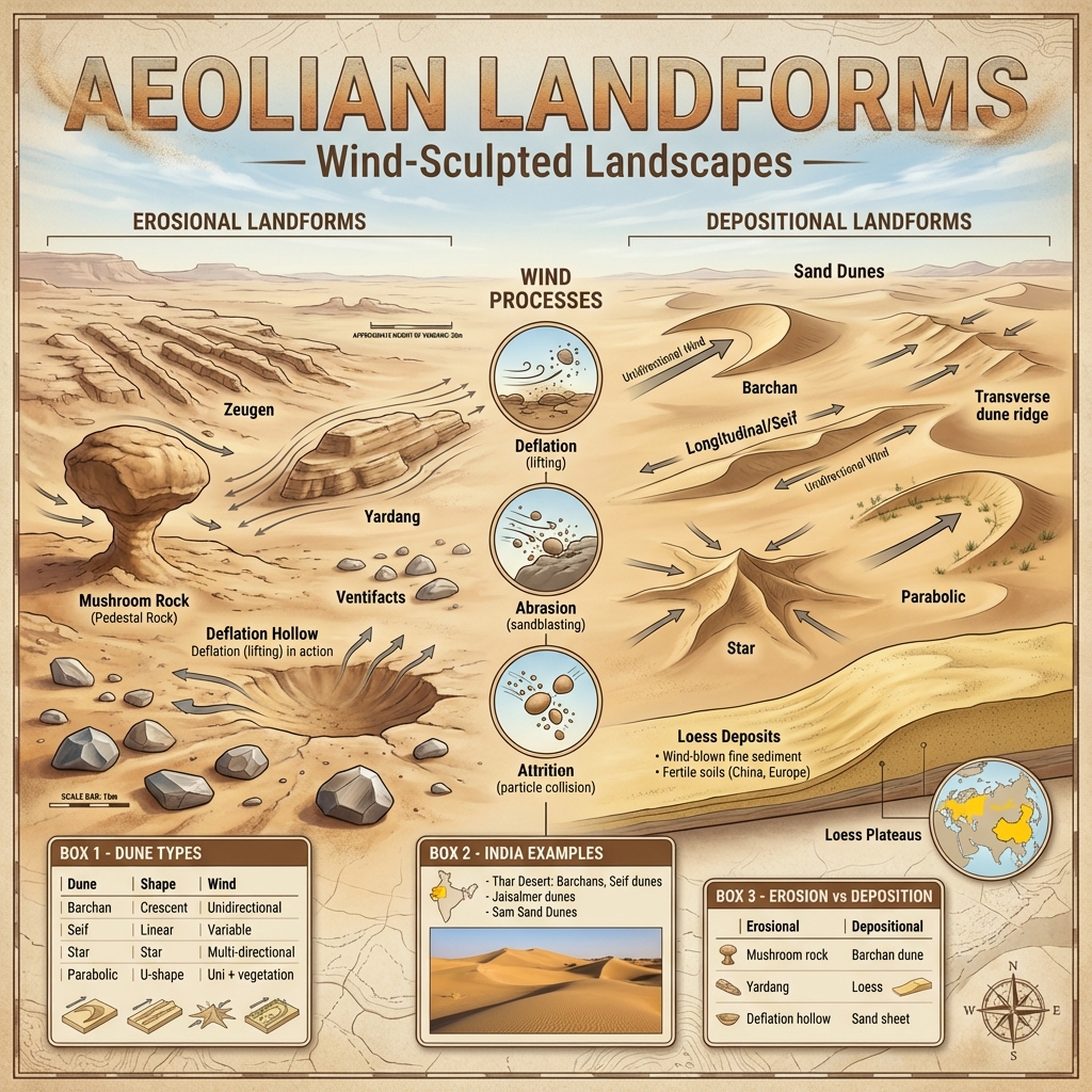
Detail aeolian landforms found in arid landscapes.Aeolian (Wind Action):
  • Erosional Features:
    • Mushroom Rocks (Pedestal Rocks): Formed by wind abrasion undercutting the lower, softer parts of rock pillars.
    • Yardangs: Alternating hard/soft rock layers running parallel to prevailing wind direction, carved into ridges.
    • Deflation Hollows: Wind-scoured depressions formed by the removal of loose, dry sand.
  • Depositional Features:
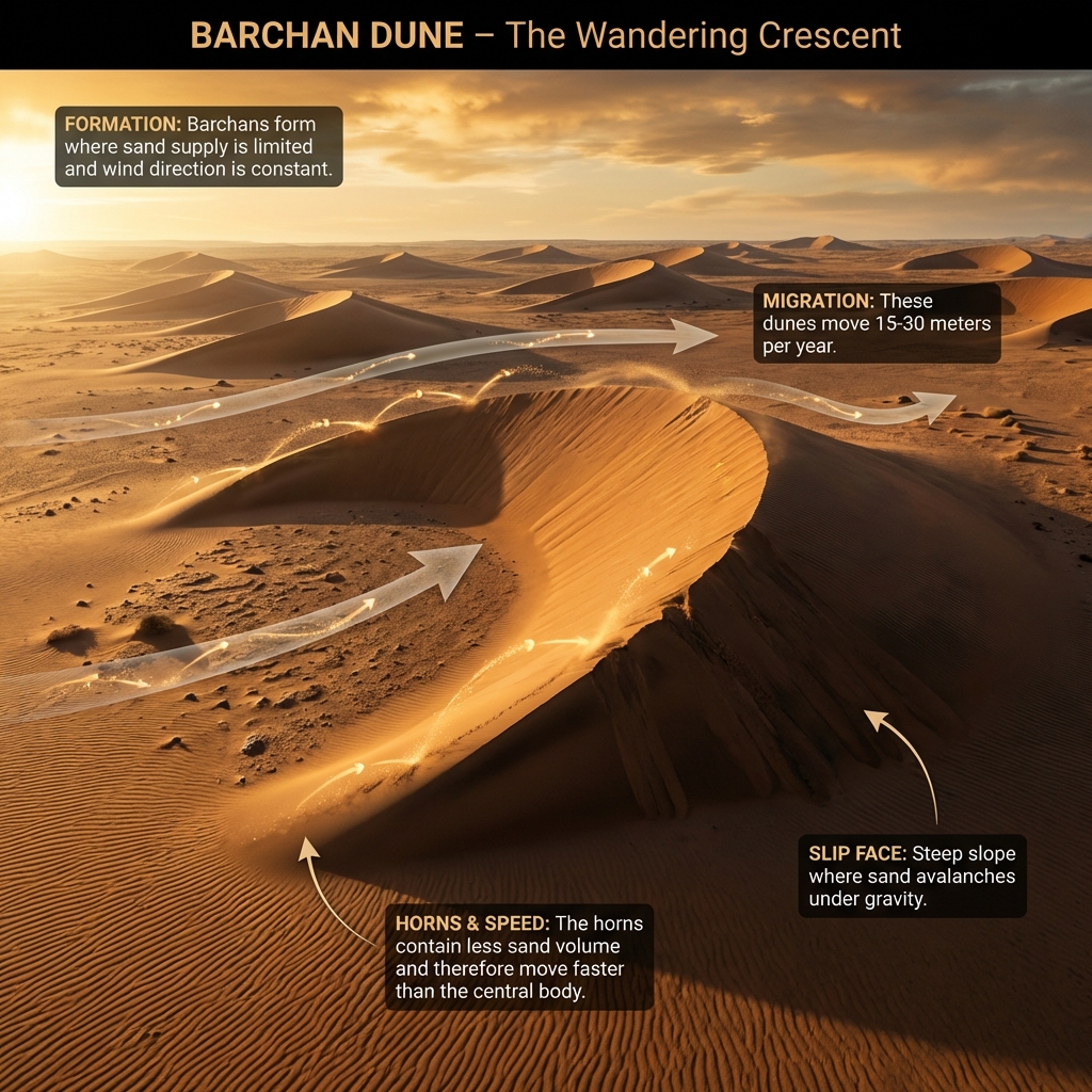
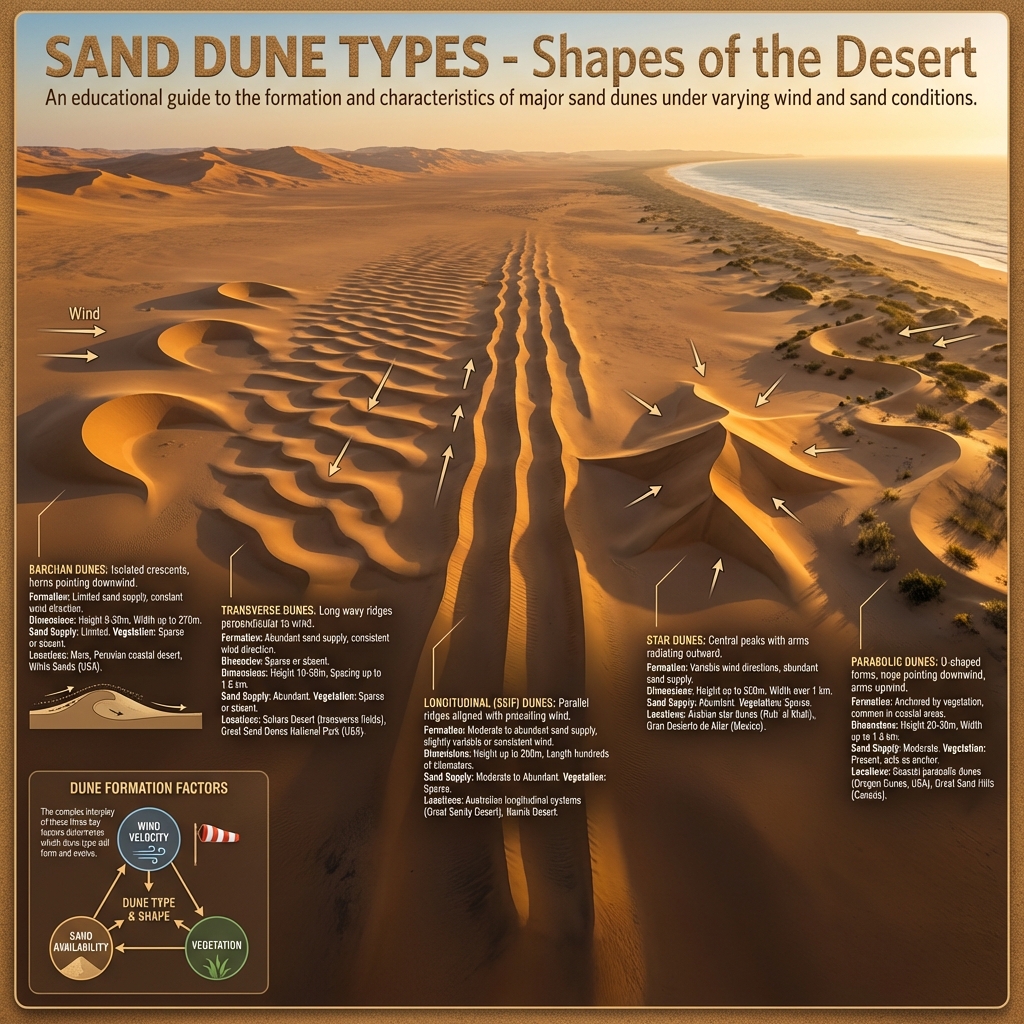
    • Sand Dunes: Migratory sand mounds. Barchans are crescent-shaped dunes with horns pointing downwind.
    • Loess: Wind-blown accumulations of extremely fine, cohesive, and fertile silt.
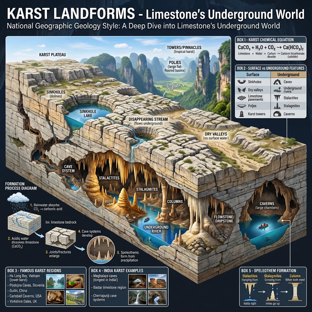
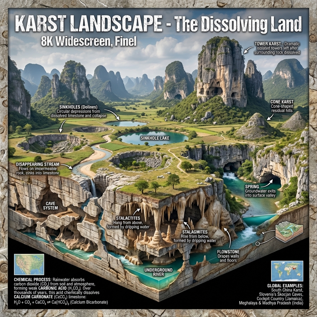
Explain the carbonation process and the landforms of Karst topography.Karst Topography (Limestone & Groundwater):
  • Carbonation Process: Groundwater rich in dissolved carbon dioxide acts on Calcium Carbonate ($CaCO_3$) limestone, converting it into soluble Calcium Bicarbonate ($Ca(HCO_3)_2$).
  • Karst Landforms:
    • Erosional/Solution: Sinkholes (depressions), swallow holes, and subterranean caves.
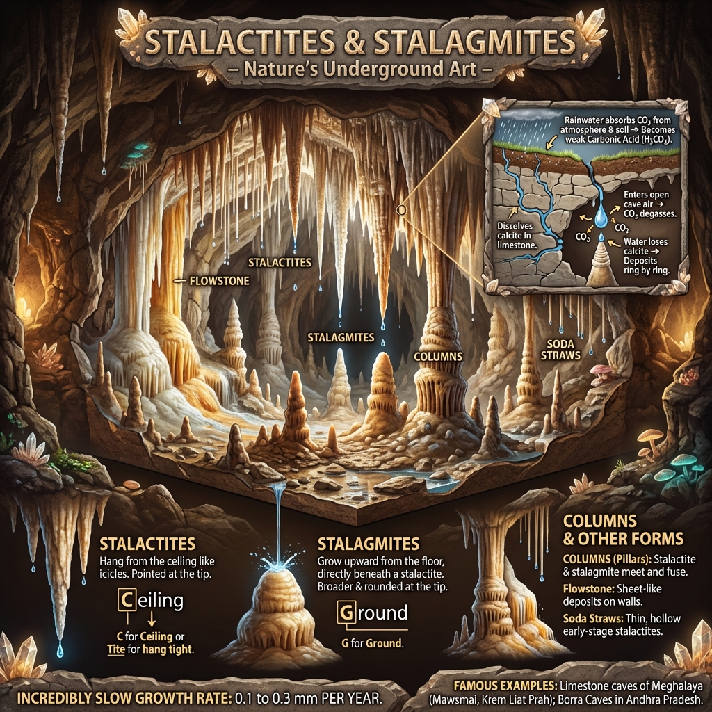
    • Depositional (Speleothems): Stalactites hanging down from the ceiling; Stalagmites growing upward from the floor; pillars where they fuse.
  • Indian Karst Regions: Kutumsar Caves (Bastar, Chhattisgarh), Belum Caves (Andhra Pradesh), Krem Liat Prah (Jaintia Hills, Meghalaya).

Coastal (Sea Wave) Landforms

Coastal (Sea Wave) Landforms
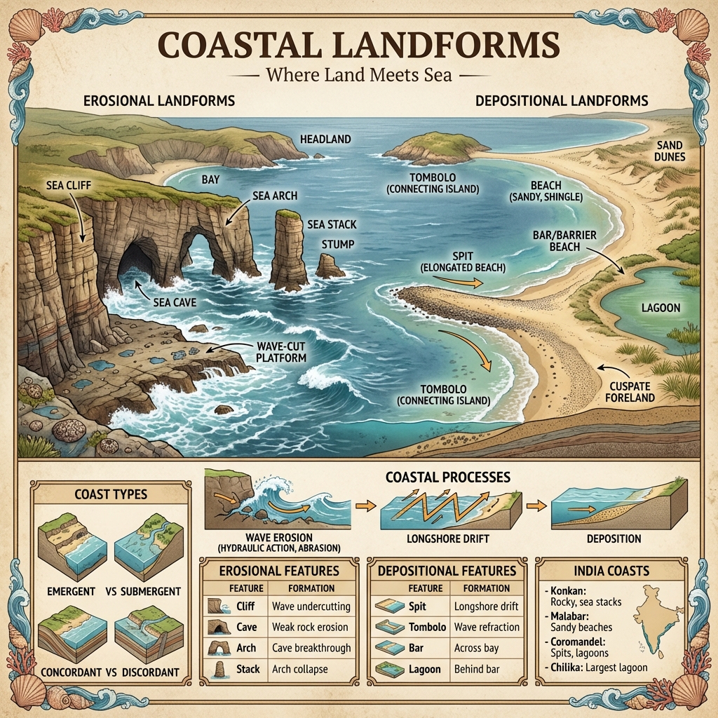
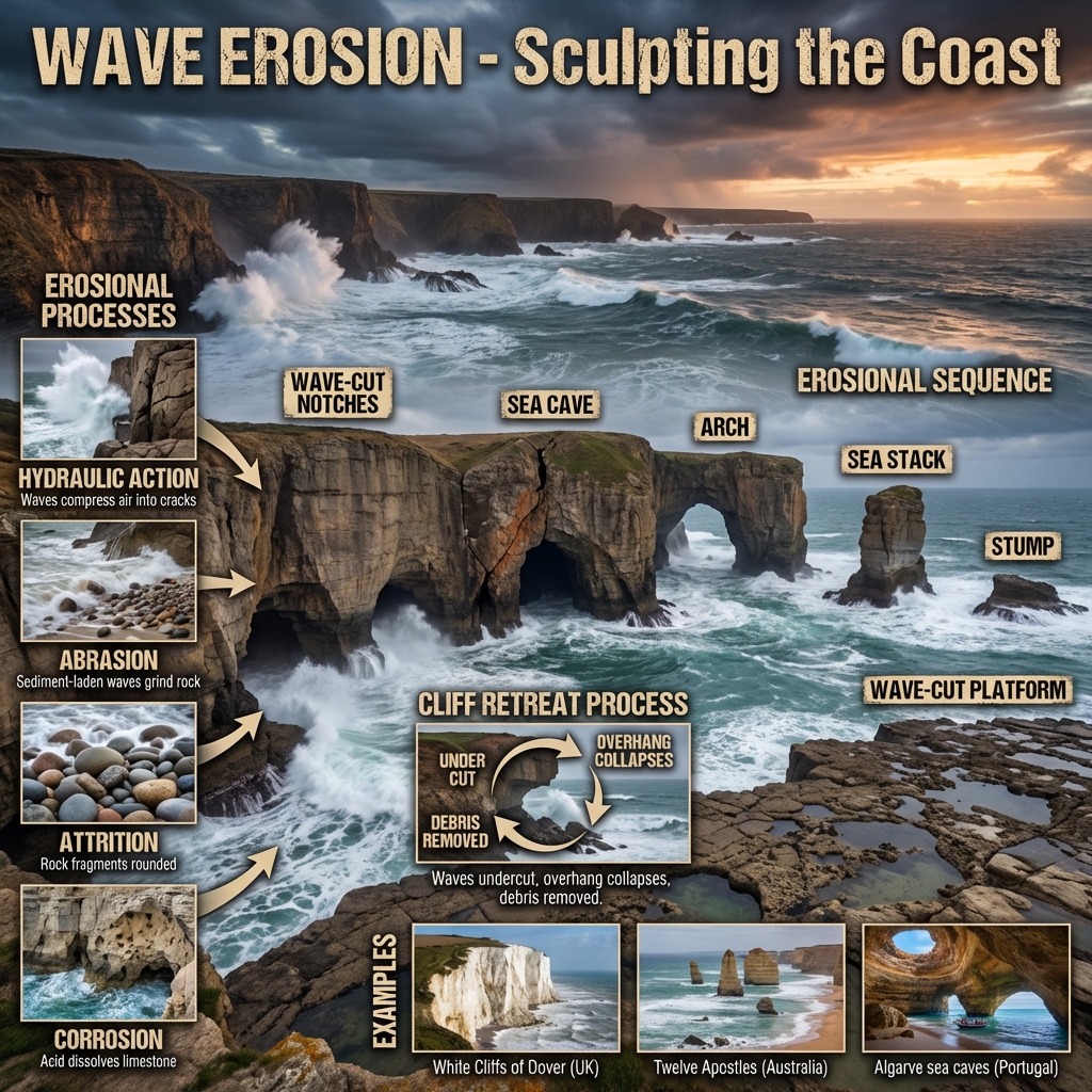
Contrast erosional and depositional wave-action features.Coastal Geomorphology:
  • Erosional Landforms:
    • Sea Cliffs & Wave-Cut Platforms: Steep vertical rock faces and flat rocky benches carved at the base by wave attack.
    • Sea Caves, Arches, and Stacks: Progressive wave excavation of jointed headlands, leaving behind isolated rock pillars (stacks).
  • Depositional Landforms:
    • Beaches & Sand Bars: Accumulations of sand/gravel on wave-sheltered coastlines, and offshore ridges of sand parallel to the beach.
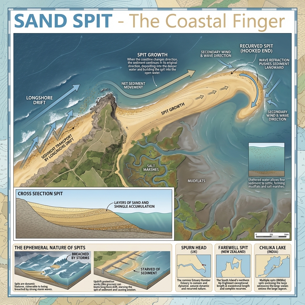
    • Spits & Hooks: Linear sand deposits attached at one end to the coast, curling at the seaward end due to longshore currents.
    • Lagoons (Kayals): Shallow water bodies separated from the open sea by sandbars (e.g., Chilika Lake, Kerala Kayals).

High-Yield UPSC Revision Pointers

  • Pingo: Ice-cored dome-like hill formed in periglacial regions by groundwater freezing under pressure.
  • Coriolis Effect: Apparent deflective force from Earth's rotation; deflects winds (right in North, left in South) and affects sand dune orientations.
  • River Capture (Stream Piracy): Geomorphic event where active headward erosion of a river breaches the divide of another river system, capturing its headwaters.
  • Base Level of Erosion: The absolute theoretical limit (mean sea level) below which a river cannot erode its valley.

Visual & Illustrative Assets


🖼️ Supplemental Asset Directory
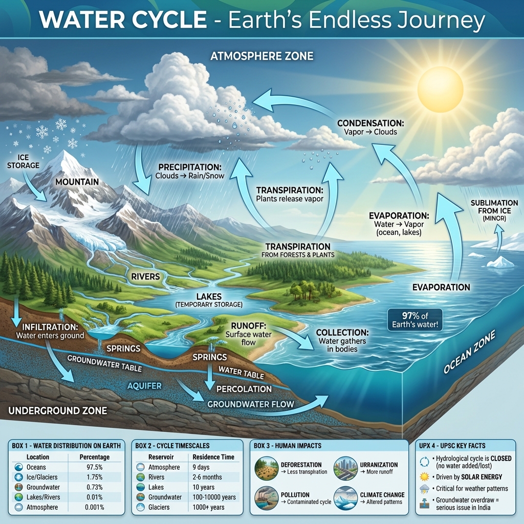
  • The Global Water Cycle: The Global Water Cycle
  • Fold Mountains: Fold Mountains
  • Block Faulting: Block Faulting
  • Horst and Graben: Horst and Graben
  • Peneplain and Monadnock (Old Age Landscape): Peneplain and Monadnock: Old Age Landscape
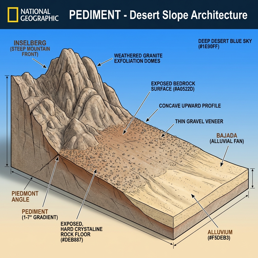
  • Pediment Landscape (Arid Erosional Form): Pediment Landscape: Arid Erosional Form
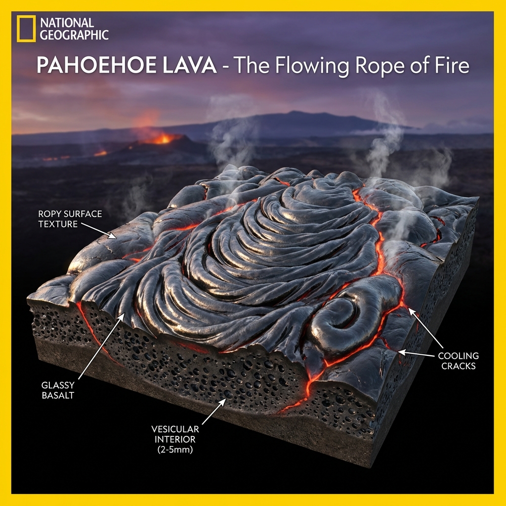
  • Pahoehoe Lava (Ropy Volcanic Flow): Pahoehoe Lava: Ropy Volcanic Flow
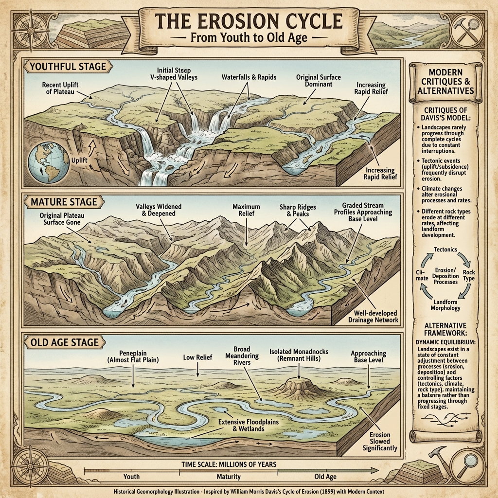
  • The Cycle of Erosion (Davisian Stage Cycle): The Cycle of Erosion: Youth, Maturity, and Old Age
  • Weathering Types and Processes: Weathering Types and Processes
  • Exfoliation Dome: Exfoliation Dome
  • Landslide Classification: Landslide Classification
  • River Delta Types (Arcuate, Bird's Foot, Cuspate): River Delta Types: Arcuate, Bird's Foot, Cuspate
  • Fluvial Landforms Overview: Fluvial Landforms Overview
  • V-Shaped vs U-Shaped Valleys: V-Shaped vs U-Shaped Valleys
  • Alluvial Fan vs Alluvial Cone: Alluvial Fan vs Alluvial Cone
  • Meander and Oxbow Lake Formation: Meander and Oxbow Lake Formation
  • Canyon and Gorge Formation: Canyon and Gorge Formation
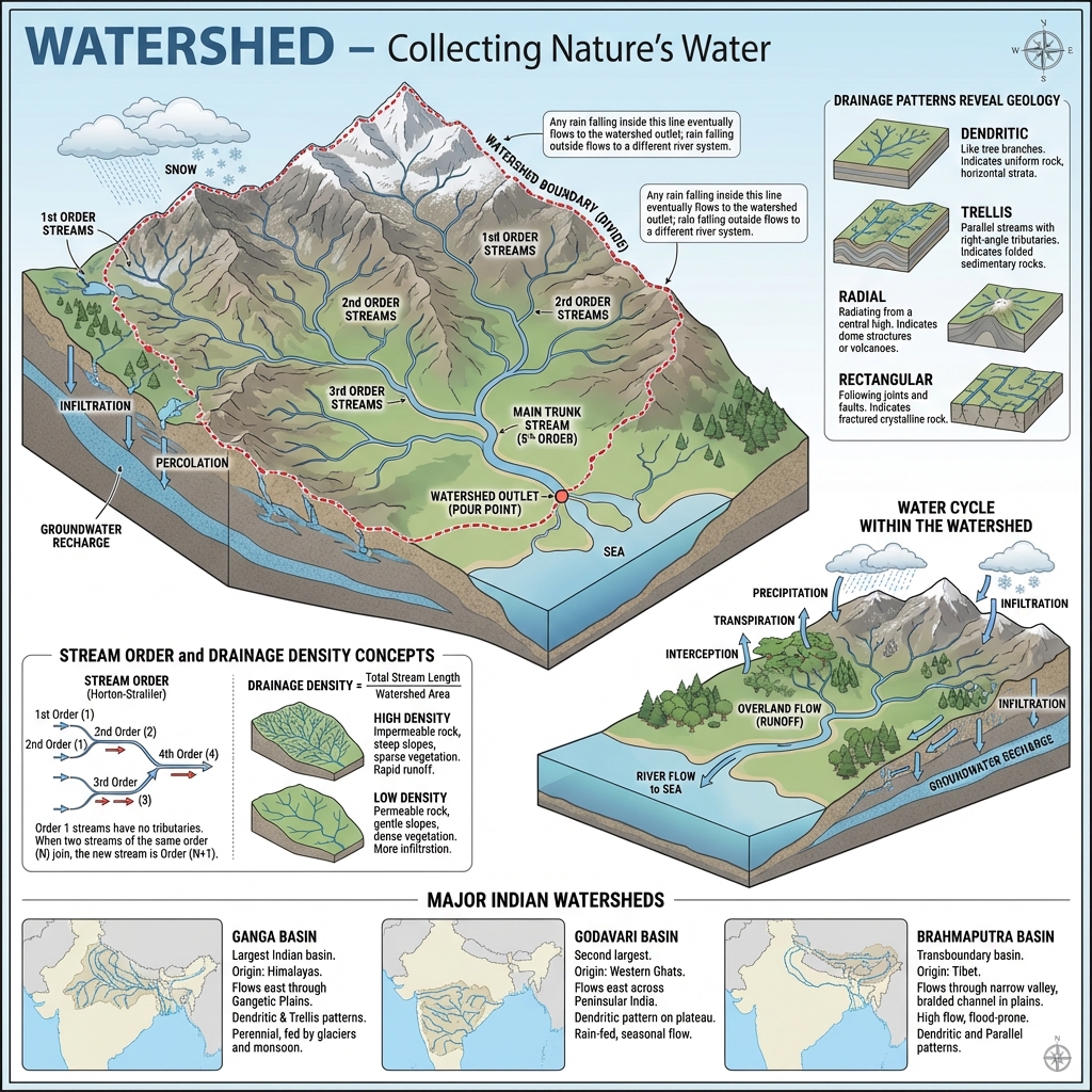
  • River Drainage Patterns (Dendritic, Trellis, Radial): River Drainage Patterns: Dendritic, Trellis, Radial
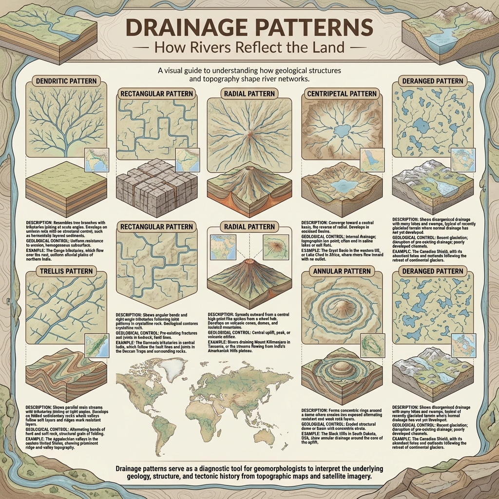
  • Watershed and Drainage Basin Anatomy: Watershed and Drainage Basin Anatomy
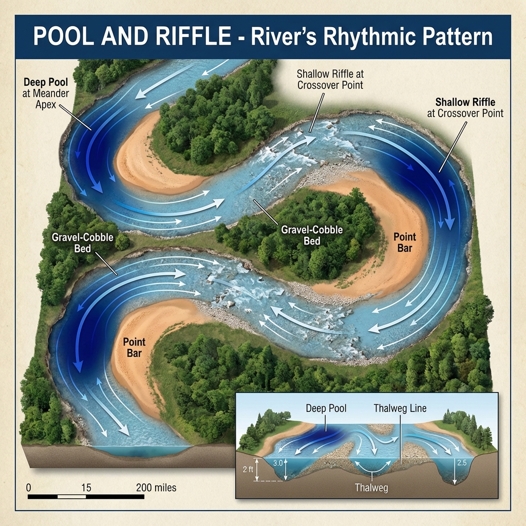
  • Pool and Riffle Sequence in Rivers: Pool and Riffle Sequence in Rivers
  • Fjord Formation (Submerged Glacial Valleys): Fjord Formation: Submerged Glacial Valleys
  • Glacial Landforms Overview: Glacial Landforms Overview
  • U-Shaped Valley Profile: U-Shaped Valley
  • Glacial Moraines Schema: Glacial Moraines
  • Cirque Glacier Anatomy: Cirque Glacier Anatomy
  • Paternoster Lakes (Chain of Glacial Lakes): Paternoster Lakes: Chain of Glacial Lakes
  • Permafrost Structure and Active Layer: Permafrost Structure and Active Layer
  • Pingo (Hydrolaccolith) Mound: Pingo (Hydrolaccolith) Mound
  • Loess Deposits and Landforms: Loess Deposits and Landforms
  • Aeolian Landforms Overview: Aeolian Landforms Overview
  • Barchan Dune Structure: Barchan Dune Structure
  • Sand Dune Types and Wind Direction: Sand Dune Types and Wind Direction
  • Karst Topography Overview: Karst Topography Overview
  • Stalactites and Stalagmites: Stalactites and Stalagmites
  • Karst Landscape Features: Karst Landscape Features and Groundwater Action
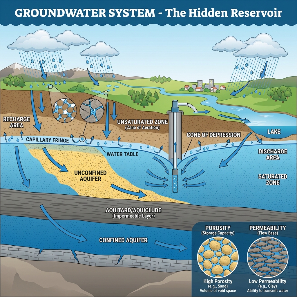
  • Groundwater System and Aquifers: Groundwater System and Aquifers
  • Coastal Landforms Overview: Coastal Landforms Overview
  • Ria Coastline Formation: Ria Coastline Formation
  • Sand Spit and Hook Formation: Sand Spit and Hook Formation
  • Wave Erosion and Coastal Landforms Evolution: Wave Erosion and Coastal Landforms Evolution
  • Landslide (Bhuskhalan) Mechanics: Landslide (Bhuskhalan) Mechanics
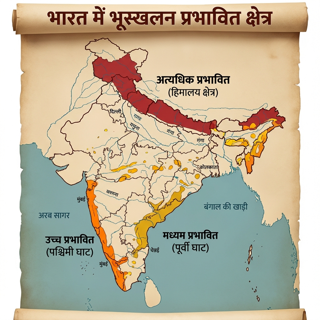
  • Landslide Hazard Zones (Bhuskhalan Kshetra): Landslide Hazard Zones (Bhuskhalan Kshetra)
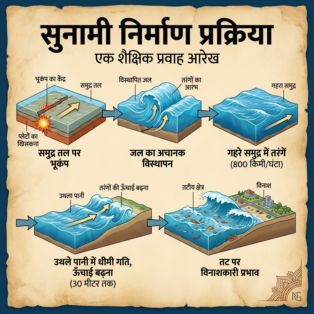
  • Tsunami (Sunami) Wave Dynamics: Tsunami (Sunami) Wave Dynamics
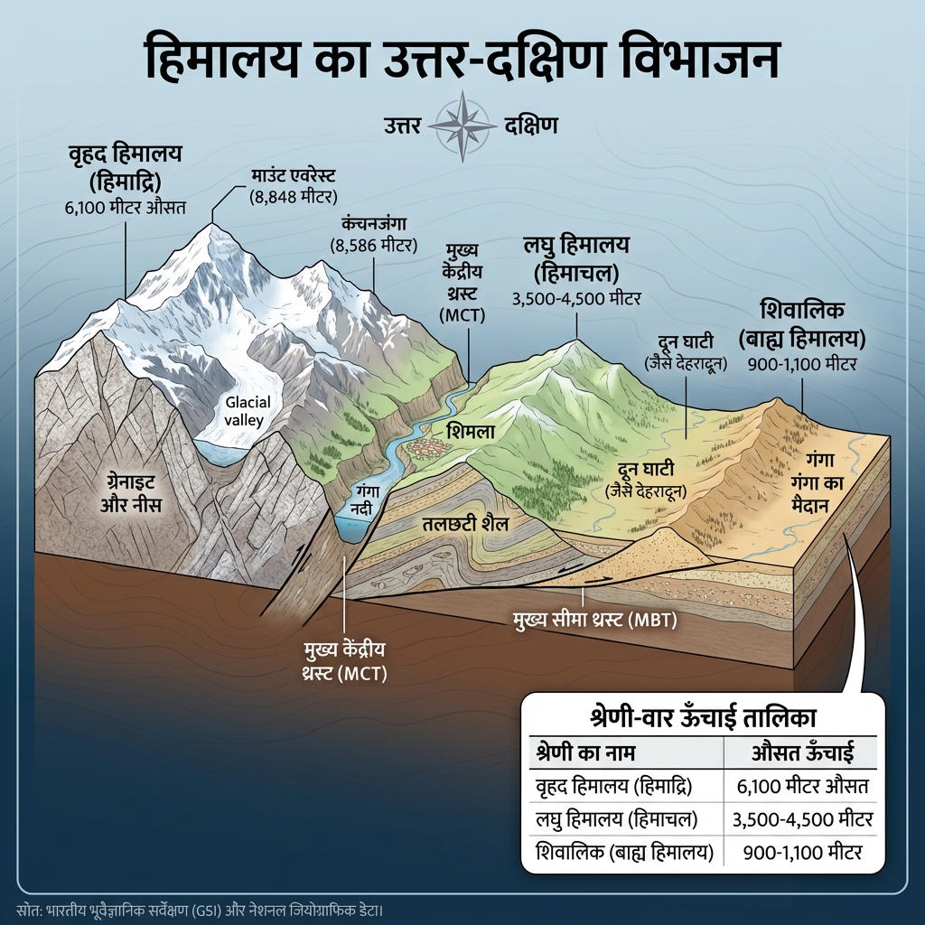
  • Himalaya: Structural Cross-Section: Himalaya: Structural Cross-Section
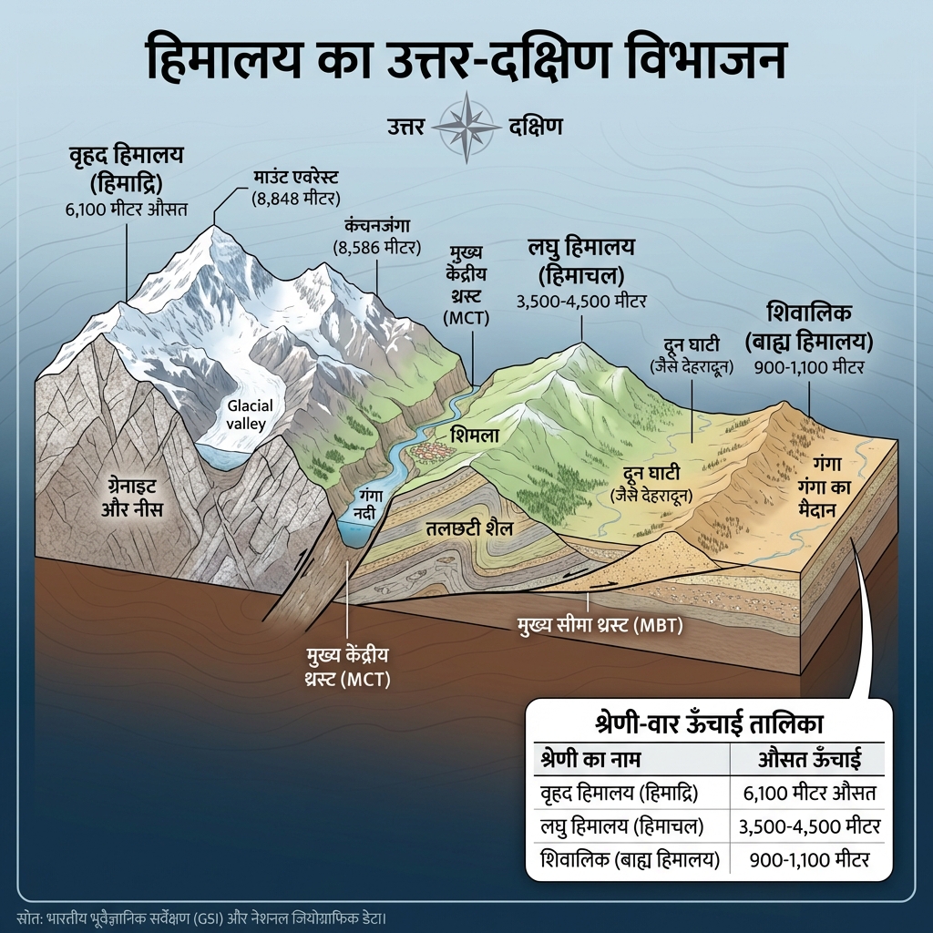
  • Himalaya: Tectonic Cross-Section v2: Himalaya: Tectonic Cross-Section v2
  • Western vs Eastern Ghats (Ghat Tulna) Comparison: Western vs Eastern Ghats (Ghat Tulna) Comparison
  • Periglacial Landscape Processes: Periglacial Landscape Processes
  • Wurm Glaciation - Historical Infographic: Wurm Glaciation - Historical Infographic
Mains Practice Questions


  • "Discuss the role of Chemical Weathering in the formation of Karst topography."
  • "Compare and contrast the landforms produced by Glacial erosion and Fluvial erosion."
  • "Explain the significance of Alluvial fans and Deltas in the human-geographical context of a region."