Skip to content

Geographical Lexicon: Terms, Concepts & Instruments

A to I: General Geography & Mapping


Terms starting with A to C

Terms starting with A to C
Define key geographical terms starting with A.Glossary: Letter A
  • Ablation: The loss of glacier ice and snow through melting, evaporation, or sublimation.
  • Abrasion: The mechanical scraping and wearing away of rock surfaces by friction from water, wind, or glacial ice.
  • Absolute Humidity: The actual mass of water vapor present per unit volume of air, expressed in grams per cubic meter ($g/m^3$).
  • Advection: The horizontal transfer of heat or other atmospheric properties through the mass movement of air.
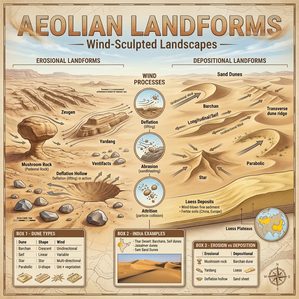
  • Aeolian: Processes, features, or landforms sculpted by wind action.
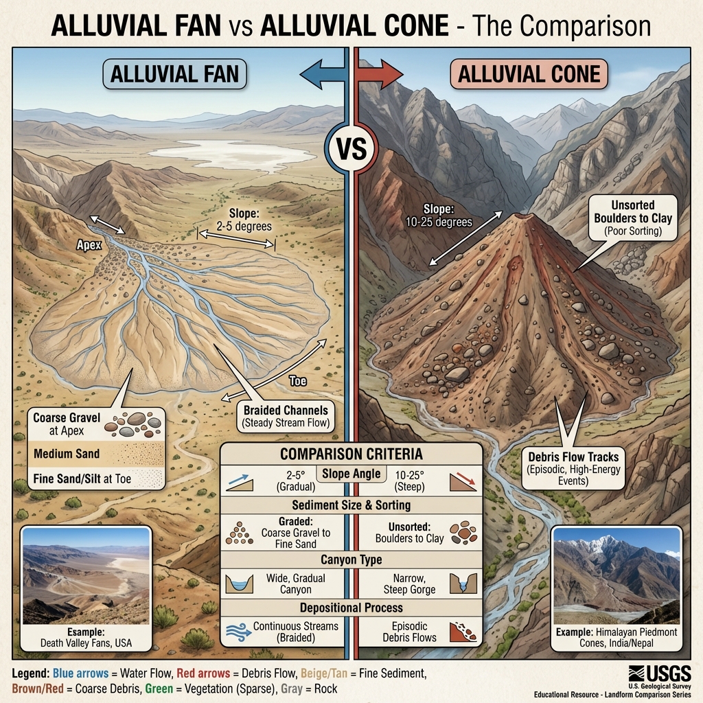
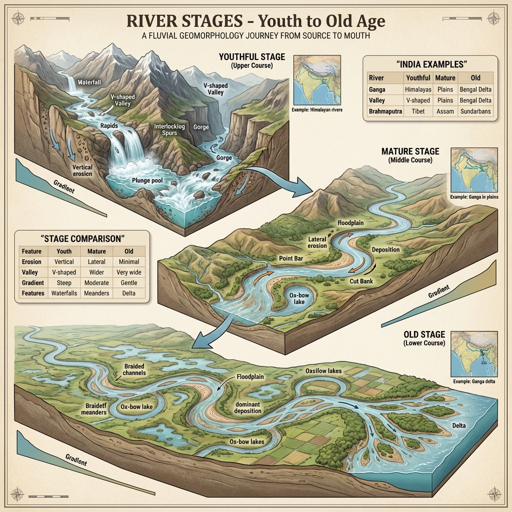
  • Alluvium: Fine silt, clay, sand, and gravel deposited by flowing water.
  • Anticline: The arch-like upward fold in rock strata (opposite of Syncline).
  • Antipodes: Two points situated diametrically opposite to each other on the Earth's surface.
  • Aphelion: The point in Earth's elliptical orbit where it is farthest from the Sun (~152 million km).
  • Apogee: The point in the Moon's orbit where it is farthest from the Earth (opposite of Perigee).
  • Atoll: A ring-shaped coral reef, island, or chain of islands surrounding a central lagoon.
  • Attrition: The wearing down of transported rock fragments through mutual collision during transit.
  • Aurora: Colorful light displays in high-latitude skies caused by solar wind interacting with Earth's magnetosphere (Aurora Borealis in the North, Aurora Australis in the South).
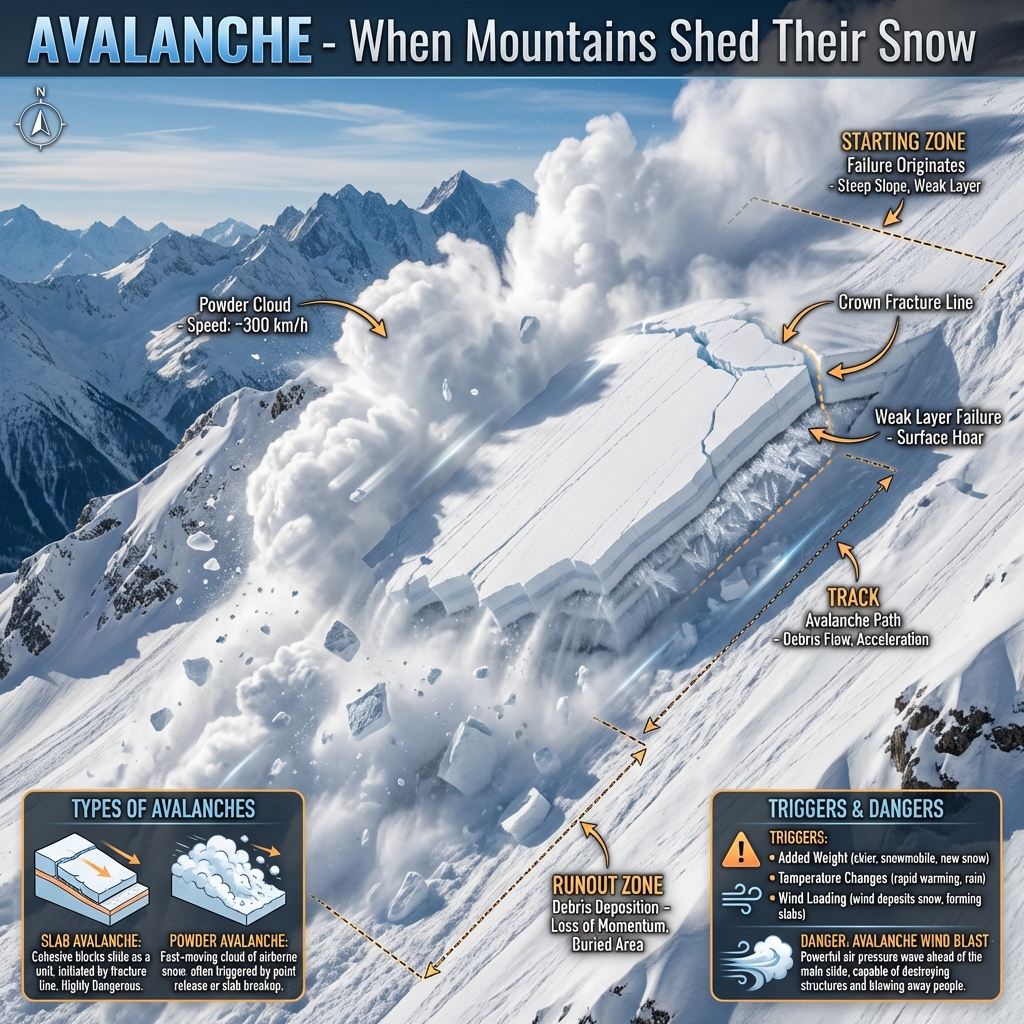
  • Avalanche: A rapid, downslope slide of a large mass of snow, ice, and rock debris.
  • Azonal Soil: Immature soil lacking well-defined, horizontal profiles.
Define key geographical terms starting with B.Glossary: Letter B
  • Barysphere (Centrosphere): The dense interior core region of the Earth lying beneath the lithosphere and mantle.
  • Base Level: The lowest limit to which a river can erode its bed (usually mean sea level).
  • Bearing: The horizontal angle measured clockwise from North (ranges from $0^{\circ}\text{ to }360^{\circ}$).
  • Biogeography: The study of the geographical distribution of plants and animals.
  • Biosphere: The global zone of life where the lithosphere, hydrosphere, and atmosphere interact.
  • Blizzard: A severe polar storm characterized by freezing temperatures, high winds, and heavy blowing snow.
  • Bog: Wet, spongy ground dominated by decaying organic matter (peat).
  • Bora: A cold, dry katabatic wind blowing from the highlands to the Adriatic coast.
  • Bore: A tidal wave that flows upstream in a narrowing river channel against the current.
Define key geographical terms starting with C.Glossary: Letter C
  • Caatinga: A dry, thorny scrub forest biome located in northeastern Brazil.
  • Canyon: A deep, narrow gorge with steep rocky sides, typically carved by river erosion.
  • Cape: A narrow headland of land jutting out into a body of water.
  • Cardinal Points: The four main compass directions: North, South, East, and West.
  • Chaparral: Mediterranean sclerophyllous evergreen scrub vegetation (found in California).

Terms starting with D to I

Terms starting with D to I
Define key geographical terms starting with E to G.Glossary: Letters E to G
  • Ecliptic: The apparent path of the Sun's yearly motion across the celestial sphere.
  • Edaphic: Environmental factors related to or influenced by the soil.
  • Epicentre: The point on the Earth's surface directly above the subterranean seismic focus (hypocentre) of an earthquake.
  • Eustatic Movement: Global changes in sea level caused by changes in the volume of water in the oceans (e.g., glacier melting).
  • Fiord (Fjord): A long, narrow, deep sea inlet bordered by steep cliffs, carved out by glacial action and subsequently submerged.
  • Fluvial: Geological processes and landforms associated with rivers and streams.
  • Great Circle: Any circle drawn on a sphere whose plane passes through the center of that sphere (e.g., the Equator).
Define key geographical terms starting with H and I.Glossary: Letters H and I
  • Hinterland: The tributary area lying behind a port or city from which it draws exports and distributes imports.
  • Horse Latitudes: Subtropical high-pressure belts located around $30^{\circ}\text{ to }35^{\circ}\text{ N/S}$ latitudes, characterized by calm winds and low precipitation.
  • ITCZ (Inter-Tropical Convergence Zone): A low-pressure belt near the equator where the trade winds of the Northern and Southern Hemispheres converge.
  • Illuviation: The accumulation of dissolved or suspended soil materials in lower soil horizons (Horizon B) due to downward percolation.
  • Insolation: The incoming short-wave solar radiation received at the Earth's surface.
  • International Date Line: An imaginary line at approximately $180^{\circ}$ longitude. Crossing it eastward subtracts a day; crossing it westward adds a day.

J to P: Physical & Biological Systems


Terms starting with J to M

Terms starting with J to M
Define key geographical terms starting with K and L.Glossary: Letters K and L
  • Karst Region: A landscape formed by the dissolution of soluble rocks like limestone, characterized by sinkholes, caves, and underground streams.
  • Katabatic Wind: A local wind carrying high-density air downslope from elevated plateaus under the force of gravity.
  • Lagoon: A shallow body of seawater separated from the open ocean by a sandbar, barrier reef, or spit (e.g., Chilika Lake).
  • Lapse Rate: The rate at which air temperature decreases with an increase in altitude (Normal Lapse Rate = $6.5^{\circ}C\text{ per km}$).
  • Latitude (Parallels): The angular distance measured in degrees north or south of the Equator.
  • Leaching: The removal of soluble minerals and nutrients from topsoil down to lower levels by percolating water.
  • Leeward: The side of a mountain or landmass that is sheltered from prevailing winds (dry rain-shadow side).
  • Light Year: The distance light travels in a vacuum in one Earth year (approx. $9.46 \times 10^{12}\text{ km}$).
  • Lithosphere: The rigid outer crustal shell of the Earth, including the crust and uppermost solid mantle.
  • Loess: Highly porous, wind-blown accumulation of fine-grained clay and silt.
  • Longitude: The angular distance measured east or west of the Prime Meridian ($0^{\circ}$ longitude at Greenwich).
  • Lunar Month: The time taken for the Moon to complete one cycle of phases relative to the Sun (~29.53 days).
Define key geographical terms starting with M.Glossary: Letter M
  • Magnetic Storms: Temporary disturbances in the Earth's magnetic field caused by solar flares and coronal mass ejections.
  • Meridian: A line of longitude running from the North Pole to the South Pole.
  • Mesophyte: A plant adapted to environments with moderate moisture supplies.
  • Mestizo: A person of mixed European and Native American ancestry.
  • Meteors: Streaks of light in the night sky ("shooting stars") produced by meteoroids burning up upon entering the atmosphere.
  • Midnight Sun: The sun remaining visible at midnight in polar latitudes during summer.
  • Monsoon: A seasonal wind pattern characterized by a complete reversal in direction.
  • Moraine: Accumulations of dirt and rocks deposited by a retreating glacier.

Terms starting with N to P

Terms starting with N to P
Define key geographical terms starting with N and O.Glossary: Letters N and O
  • Nivation: The erosion of rock and soil beneath snow patches due to freeze-thaw cycles.
  • Nomadism: A way of life where communities move from place to place for pasture, water, or food.
  • Ocean Current: A continuous, directed movement of seawater driven by wind, temperature, salinity, and Earth's rotation.
  • Orbit: The gravitationally curved path of an object around a point in space.
  • Orographic Rain: Precipitation produced when moisture-laden air is forced to rise over a mountain range.
  • Outwash Plain: A flat plain of glacial gravel and sand deposited by meltwater streams at the margin of a glacier.
Define key geographical terms starting with P.Glossary: Letter P
  • Pampas: Vast temperate grasslands of South America, primarily in Argentina.
  • Pastoralism: Livestock raising as the primary economic activity, often practiced semi-nomadically.
  • Pedology: The scientific study of soils, their formation, morphology, and classification.
  • Pelagic: Relating to or living in the open ocean water column (excluding the sea floor).
  • Peninsula: A piece of land surrounded by water on three sides.
  • Perigee: The point in the Moon's orbit closest to the Earth (opposite of Apogee).
  • Perihelion: The point in Earth's orbit closest to the Sun (~147 million km).
  • Permafrost: Ground that remains completely frozen (below $0^{\circ}C$) for two or more consecutive years.
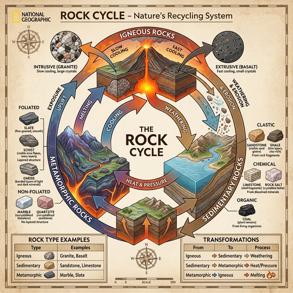
  • Petrology: The branch of geology studying the origin, composition, structure, and alteration of rocks.
  • Phenology: The study of periodic biological phenomena (like bird migrations or plant flowering) in relation to climatic changes.
  • Phytogeography: The study of the geographic distribution of plant species.
  • Piedmont: An area of rolling hills lying at the foot of a mountain range.
  • Planetary Winds: Large-scale global winds that blow consistently throughout the year in response to pressure belts.
  • Plateau: A broad, elevated area of relatively flat land.
  • Prairies: Extensive temperate grasslands of North America.
  • Precipitation: All forms of moisture falling from the atmosphere to Earth's surface (rain, snow, sleet, hail).
  • Pressure Gradient: The rate of change in atmospheric pressure over horizontal distance.

R to Z: Space & Natural Systems


Terms starting with R to S

Terms starting with R to S
Define key geographical terms starting with R.Glossary: Letter R
  • Radiation: The emission and transmission of energy in the form of electromagnetic waves or particles.
  • Rain Shadow: A dry area on the leeward side of a mountain range where precipitation is significantly lower.
  • Reef: A ridge of rock, sand, or coral lying close to the surface of the water.
  • Reg: A desert surface covered with closely packed, smooth, wind-polished pebbles (stony desert).
  • Rhumb Line (Loxodrome): A line on the Earth's surface cutting all meridians of longitude at the same angle; represents a path of constant compass bearing.
Define key geographical terms starting with S.Glossary: Letter S
  • Saprophyte: A plant, fungus, or microorganism that draws nutrition from decaying organic matter.
  • Satellite: An object orbiting a planet, which can be natural (e.g., the Moon) or artificial (e.g., communication satellites).
  • Savanna: A mixed woodland-grassland ecosystem characterized by trees being sufficiently widely spaced.
  • Seismology (Seismograph): The study of earthquakes and seismic waves; measured using a seismograph.
  • Selvas: The dense, species-rich equatorial tropical rainforests of the Amazon Basin.
  • Sericulture: The commercial rearing of silkworms for the production of silk.
  • Sidereal Day: The time taken for Earth to rotate once on its axis relative to distant stars ($23\text{ hours }56\text{ minutes }4\text{ seconds}$).
  • Sleet: Precipitation consisting of small, translucent pellets of ice formed by the freezing of rain.
  • Smog: A mixture of smoke and fog, common in industrial or urban basins.
  • Snow-line: The lowest altitude at which snow accumulation matches ablation, leaving snow year-round.
  • Soil Erosion: The displacement and transport of upper soil layers by water or wind.
  • Solar Constant: The rate at which solar energy is received per unit area at the outer limit of Earth's atmosphere ($~1,361\text{ W/m}^2$).
  • Solar Day: The time interval between two successive transits of the Sun across the local meridian ($24\text{ hours}$).
  • Solstice: The two annual periods when the Sun reaches its maximum northern (Summer Solstice) or southern (Winter Solstice) declination relative to the equator.
  • Steppe: Semi-arid temperate grasslands of Eurasia.
  • Strait: A narrow passage of water connecting two larger bodies of water.
  • Syncline: A trough-like downward fold in rock strata (opposite of Anticline).
  • Sublimation: The direct phase transition from solid to gas (or vice-versa) bypassing the liquid phase.

Terms starting with T to Z

Terms starting with T to Z
Define key geographical terms starting with T.Glossary: Letter T
  • Taiga: Subarctic needleleaf evergreen coniferous forest biome.
  • Temperature Inversion: An atmospheric anomaly where temperature increases with height.
  • Thermograph: An instrument that automatically records variations in temperature.
  • Tidal Range: The vertical difference in height between consecutive high and low tides.
  • Topographic Map: A detailed, large-scale map showing physical landforms and contours.
  • Transhumance: The seasonal movement of livestock and herders between high mountain pastures in summer and valleys in winter.
  • Tributary: A river or stream that flows into a larger main river.
  • Tropics: The region between the Tropic of Cancer ($23.5^{\circ}\text{N}$) and the Tropic of Capricorn ($23.5^{\circ}\text{S}$).
  • Tropophyte: A plant adapted to seasonal moisture fluctuations, behaving as a hygrophyte in wet seasons and a xerophyte in dry seasons.
  • Tsunami: A series of giant ocean waves generated by submarine earthquakes or volcanic eruptions.
Define key geographical terms starting with V to Z.Glossary: Letters V to Z
  • Van Allen Belts: Bands of highly energetic charged particles trapped by Earth's magnetic field at altitudes of ~3,000 km and ~16,000 km.
  • Viticulture: The science, production, and study of grapes, especially for winemaking.
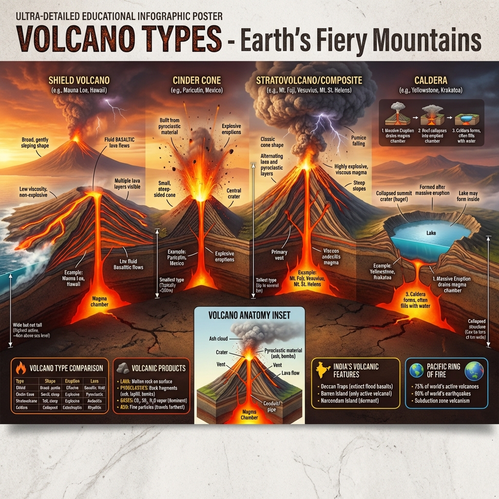
  • Volcano: A rupture in the Earth's crust that allows hot lava, volcanic ash, and gases to escape from a magma chamber.
  • Watershed: An elevated drainage divide separating adjacent river basins.
  • Willy-willy: A local term used in Australia for tropical cyclones.
  • Xerophyte: A plant species adapted to survive in dry, arid habitats with minimal water.
  • Yazoo River: A tributary river that runs parallel to the main river for a long distance before merging, kept separate by natural levees.
  • Zenith: The point in the celestial sphere vertically above the observer.
  • Zodiac: A band of the sky extending about $8^{\circ}$ on either side of the ecliptic, containing the paths of the sun, moon, and planets.
  • Zonal Soil: Well-developed soils whose characteristics are determined primarily by long-term regional climate and vegetation.
  • Zoogeography: The study of the geographic distribution of animal species.
  • Zoophyte: An invertebrate animal that resembles a plant (e.g., coral polyp).

Scientific Instruments & Mapping Lines


Scientific Measurement Instruments

Scientific Measurement Instruments
List key scientific instruments and explain their functions.Instruments Index:
  • Altimeter: Measures altitude (commonly an aneroid barometer used in aircraft).
  • Anemometer: Measures wind speed and velocity.
  • Barometer (Barograph): Measures atmospheric pressure; a barograph records it continuously.
  • Chronometer: An exceptionally precise time-keeping instrument used in marine navigation to determine longitude.
  • Clinometer: Measures angles of slope, elevation, or tilt of an object.
  • Fathometer: An instrument used to measure the depth of water using acoustic echoes.
  • Hyetograph: An instrument that automatically records rainfall amount and intensity.
  • Hygrometer: Measures the relative humidity of the atmosphere.
  • Planimeter: A mechanical instrument used to measure the area of irregular 2D shapes on maps.
  • Theodolite: A precision optical instrument used by surveyors to measure horizontal and vertical angles.

Isopleths (Mapping Lines)

Isopleths (Mapping Lines)
Identify the names of different isopleth lines used on maps.Isarithm Lines Database:
  • Isobars: Lines of equal atmospheric pressure.
  • Isobaths: Lines of equal underwater depth in seas or lakes.
  • Isobronts: Lines connecting points experiencing simultaneous thunderstorms.
  • Isochrones: Lines showing equal travel time from a common starting point.
  • Isogonals: Lines of equal magnetic declination.
  • Isohalines: Lines of equal salinity in water bodies.
  • Isohels: Lines of equal duration of sunshine.
  • Isohyets: Lines of equal precipitation (rainfall).
  • Isohypses (Contours): Lines connecting points of equal elevation above sea level.
  • Isonifs: Lines of equal snow accumulation.
  • Isophenes: Lines connecting points where biological events (e.g., plant flowering) occur at the same time.
  • Isopotentials: Lines connecting the level to which artesian water will rise.
  • Isorymes: Lines of equal frost lines.
  • Isoseismals: Lines connecting points of equal earthquake shaking intensity.
  • Isotherms: Lines of equal air temperature.

High-Yield UPSC Revision Pointers

  • Dobson Unit (DU): Measures column ozone; not to be confused with general isopleths.
  • Planimeter vs Theodolite: A Planimeter measures flat areas on maps, whereas a Theodolite measures geodetic angles in the field.
  • Sidereal vs Solar Day: A Sidereal Day is 3 minutes 56 seconds shorter than a Solar Day because the Earth must rotate slightly more than $360^{\circ}$ to align with the sun due to orbital motion.
  • Yazoo River: Formed when the tributary cannot breach the high natural levees built by the main river (e.g., Yazoo River parallel to the Mississippi River).

Visual & Illustrative Assets


🖼️ Supplemental Asset Directory
  • Aeolian Landforms: Aeolian (Wind-blown) Landforms
  • Alluvial Deposits (Fan vs Cone): Alluvial Deposits: Fan vs Cone
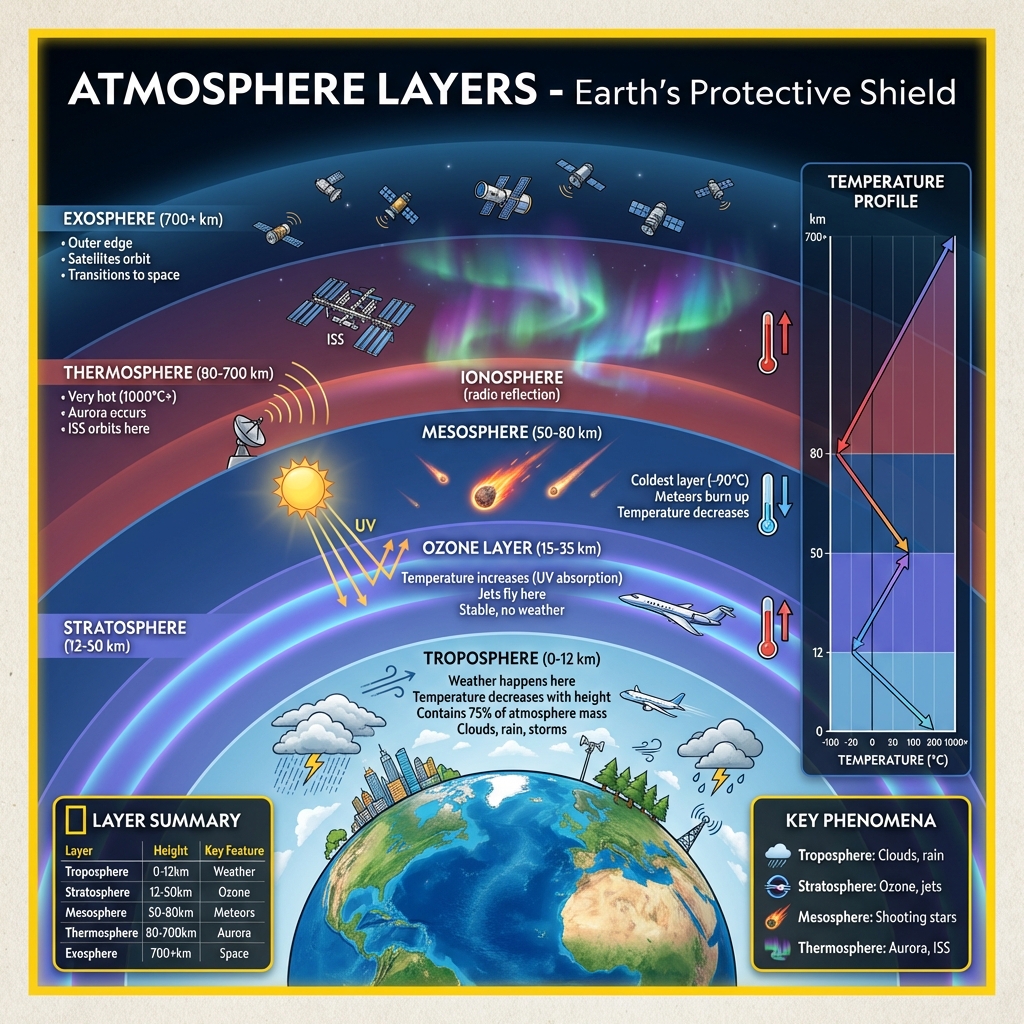
  • Atmospheric Layers and Composition: Atmospheric Layers and Composition
  • Avalanche Mechanics and Impact: Avalanche Mechanics and Impact
  • River Evolution Stages: River Evolution Stages: Youth, Maturity, Old Age
  • The Rock Cycle: The Rock Cycle: Transformation of Crustal Materials
  • Volcano Types and Structures: Volcano Types and Internal Structures

Mains Practice Questions


  • "Evaluate the significance of geodetic measurement tools like the Theodolite and Planimeter in spatial surveying."
  • "Describe the astronomical differences between a Sidereal Day and a Solar Day."
  • "Analyze how the identification of Isopleth patterns (e.g., Isohyets and Isotherms) assists in agricultural planning."